Suszec geodata
Suszec (Silesia) is a seat of a third-order administrative division; located in Poland in Europe/Warsaw (GMT+2) time zone. With population of 4,183 people, there are 783 cities with bigger population in this country. Compared to other cities in Poland, 80.9% of cities are located further ↑North; 63.5% of cities are located further →East and 79.8% of cities have lower elevation than Suszec. Note1


Suszec GPS coordinates[2]
50° 1' 46.488" North, 18° 47' 29.76" East
| Map corner | latitude | longitude |
|---|---|---|
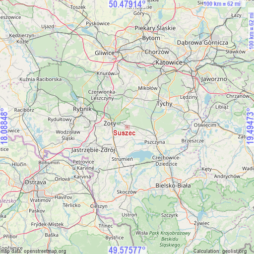
| Upper-left | 50.47914°, | 18.08848° |
| Center: | 50.02958°, | 18.7916° |
| Lower-right: | 49.57577°, | 19.49473° |
| Map W x H: | 100.4×100.4 km | = 62.4×62.4mi |
| max Lat: | 54.83135° ⇑80.9% North |
| Suszec: | 50.02958° |
| min Lat: | ⇓19.1% South 49.21328° |
| min Long | Suszec | max Long |
| 14.20249° | 18.7916° | 24.03723° |
| W 36.5%⇐ | ⇒63.5% E |
Elevation
Elevation of Suszec is 265 m = 869 ft, and this is 73.6 m = 241 ft above average elevation for this country.
| Max E: |
974 m = 3196 ft | 20.2% |
| Suszec | 265 m 869 ft | |
| Avg. | 191.4 m = 628 ft | |
Min E: |
-3 m = -10 ft | 79.8% |
See also: Poland elevation on elevation.city.
Geographical zone
Suszec is located in North temperate zone (between Tropic of Cancer and the Arctic Circle). Distance of this North polar circle is 1838.4 km =1142.3 mi to North.| Distance of | km | miles | from Suszec |
|---|---|---|---|
| North Pole | 4444.3 | 2761.6 | to North |
| Arctic Circle | 1838.4 | 1142.3 | to North |
| Tropic Cancer | 2956.8 | 1837.3 | to South |
| Equator | 5562.8 | 3456.6 | to South |


Nearby cities:
15 places around Suszec: (largest is in red/bold)
• Bełk
12.4 km =7.7 mi,  334°
334°
• Czarków
8.3 km =5.2 mi,  98°
98°
• Gardawice
9.7 km =6 mi,  3°
3°
• Gostyń
10.6 km =6.6 mi,  37°
37°
• Kobiór
10.8 km =6.7 mi,  71°
71°
• Kryry
1.8 km =1.1 mi,  144°
144°
• Krzyżowice
9.8 km =6.1 mi,  239°
239°
• Pawłowice
9.2 km =5.7 mi,  214°
214°
• Piasek
11.4 km =7.1 mi, 100°
• Radostowice
7 km =4.3 mi,  114°
114°
• Rudziczka
2.2 km =1.4 mi,  289°
289°
• Strumień
12.2 km =7.6 mi,  188°
188°
• Studzionka
7.6 km =4.7 mi, 190°
• Zbytków
12.7 km =7.9 mi,  201°
201°
• Żory
6.7 km =4.2 mi,  284°
284°
Sources, notices
• [Note1] Compared only with cities in Poland existing in our database
• [Src1] Map data: © OpenStreetMap contributors (CC-BY-SA)
• [Src2] Other city data from geonames.org with taken over terms of usage.
• [Src3] Geographical zone / Annual Mean Temperature by Robert A. Rohde @ Wikipedia
