Pawłowice geodata
Pawłowice (Silesia) is a populated place; located in Poland in Europe/Warsaw (GMT+2) time zone. With population of 9,929 people, there are 449 cities with bigger population in this country. Compared to other cities in Poland, 84.8% of cities are located further ↑North; 64.8% of cities are located further →East and 79.7% of cities have lower elevation than Pawłowice. Note1


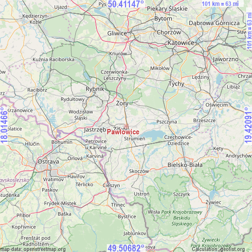
Pawłowice GPS coordinates[2]
49° 57' 40.572" North, 18° 43' 4.008" East
| Map corner | latitude | longitude |
|---|---|---|
| Upper-left | 50.41147°, | 18.01466° |
| Center: | 49.96127°, | 18.71778° |
| Lower-right: | 49.50682°, | 19.42091° |
| Map W x H: | 100.6×100.6 km | = 62.5×62.5mi |
| max Lat: | 54.83135° ⇑84.8% North |
| Pawłowice: | 49.96127° |
| min Lat: | ⇓15.2% South 49.21328° |
| min Long | Pawłowice | max Long |
| 14.20249° | 18.71778° | 24.03723° |
| W 35.2%⇐ | ⇒64.8% E |
Elevation
Elevation of Pawłowice is 264 m = 866 ft, and this is 72.6 m = 238 ft above average elevation for this country.
| Max E: |
974 m = 3196 ft | 20.3% |
| Pawłowice | 264 m 866 ft | |
| Avg. | 191.4 m = 628 ft | |
Min E: |
-3 m = -10 ft | 79.7% |
See also: Poland elevation on elevation.city.
Geographical zone
Pawłowice is located in North temperate zone (between Tropic of Cancer and the Arctic Circle). Distance of this North polar circle is 1846 km =1147.1 mi to North.| Distance of | km | miles | from Pawłowice |
|---|---|---|---|
| North Pole | 4451.9 | 2766.3 | to North |
| Arctic Circle | 1846 | 1147.1 | to North |
| Tropic Cancer | 2949.3 | 1832.6 | to South |
| Equator | 5555.2 | 3451.8 | to South |


Nearby cities:
15 places around Pawłowice: (largest is in red/bold)
• Bąków
7.5 km =4.7 mi,  181°
181°
• Chybie
10.2 km =6.3 mi,  129°
129°
• Frelichów
8.9 km =5.5 mi, 130°
• Gogołowa
9.5 km =5.9 mi,  287°
287°
• Kryry
8.8 km =5.5 mi,  45°
45°
• Krzyżowice
4.2 km =2.6 mi,  309°
309°
• Mnich
10.2 km =6.3 mi,  141°
141°
• Pielgrzymowice
7.9 km =4.9 mi,  218°
218°
• Rudziczka
8.9 km =5.5 mi,  20°
20°
• Strumień
5.7 km =3.5 mi, 142°
• Studzionka
3.9 km =2.4 mi,  88°
88°
• Suszec
9.2 km =5.7 mi,  34°
34°
• Zabłocie
7.9 km =4.9 mi, 144°
• Zbytków
4.3 km =2.7 mi,  171°
171°
• Żory
9.4 km =5.8 mi,  352°
352°
Sources, notices
• [Note1] Compared only with cities in Poland existing in our database
• [Src1] Map data: © OpenStreetMap contributors (CC-BY-SA)
• [Src2] Other city data from geonames.org with taken over terms of usage.
• [Src3] Geographical zone / Annual Mean Temperature by Robert A. Rohde @ Wikipedia
