Strumień geodata
Strumień (Silesia) is a seat of a third-order administrative division; located in Poland in Europe/Warsaw (GMT+2) time zone. With population of 3,419 people, there are 930 cities with bigger population in this country. Compared to other cities in Poland, 86.6% of cities are located further ↑North; 64% of cities are located further →East and 78.1% of cities have lower elevation than Strumień. Note1


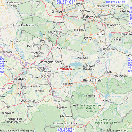
Strumień GPS coordinates[2]
49° 55' 15.708" North, 18° 45' 58.932" East
| Map corner | latitude | longitude |
|---|---|---|
| Upper-left | 50.37161°, | 18.06325° |
| Center: | 49.92103°, | 18.76637° |
| Lower-right: | 49.4662°, | 19.4695° |
| Map W x H: | 100.7×100.7 km | = 62.6×62.6mi |
| max Lat: | 54.83135° ⇑86.6% North |
| Strumień: | 49.92103° |
| min Lat: | ⇓13.4% South 49.21328° |
| min Long | Strumień | max Long |
| 14.20249° | 18.76637° | 24.03723° |
| W 36%⇐ | ⇒64% E |
Elevation
Elevation of Strumień is 258 m = 846 ft, and this is 66.6 m = 219 ft above average elevation for this country.
| Max E: |
974 m = 3196 ft | 21.9% |
| Strumień | 258 m 846 ft | |
| Avg. | 191.4 m = 628 ft | |
Min E: |
-3 m = -10 ft | 78.1% |
See also: Poland elevation on elevation.city.
Geographical zone
Strumień is located in North temperate zone (between Tropic of Cancer and the Arctic Circle). Distance of this North polar circle is 1850.5 km =1149.8 mi to North.| Distance of | km | miles | from Strumień |
|---|---|---|---|
| North Pole | 4456.4 | 2769.1 | to North |
| Arctic Circle | 1850.5 | 1149.8 | to North |
| Tropic Cancer | 2944.8 | 1829.8 | to South |
| Equator | 5550.7 | 3449 | to South |


Nearby cities:
15 places around Strumień: (largest is in red/bold)
• Bąków
4.8 km =3 mi,  230°
230°
• Chybie
4.8 km =3 mi,  115°
115°
• Drogomyśl
5.8 km =3.6 mi,  186°
186°
• Frelichów
3.5 km =2.2 mi,  111°
111°
• Krzyżowice
9.8 km =6.1 mi,  316°
316°
• Mnich
4.6 km =2.9 mi,  140°
140°
• Ochaby
8.7 km =5.4 mi,  178°
178°
• Pawłowice
5.7 km =3.5 mi, 322°
• Pielgrzymowice
8.6 km =5.3 mi,  258°
258°
• Pierściec
10.3 km =6.4 mi,  160°
160°
• Pruchna
8.7 km =5.4 mi,  224°
224°
• Studzionka
4.6 km =2.9 mi,  5°
5°
• Zaborze
6 km =3.7 mi,  153°
153°
• Zabłocie
2.3 km =1.4 mi, 151°
• Zbytków
2.8 km =1.7 mi,  274°
274°
Sources, notices
• [Note1] Compared only with cities in Poland existing in our database
• [Src1] Map data: © OpenStreetMap contributors (CC-BY-SA)
• [Src2] Other city data from geonames.org with taken over terms of usage.
• [Src3] Geographical zone / Annual Mean Temperature by Robert A. Rohde @ Wikipedia
