Kryry geodata
Kryry (Silesia) is a populated place; located in Poland in Europe/Warsaw (GMT+2) time zone. With population of 1,349 people, there are 2021 cities with bigger population in this country. Compared to other cities in Poland, 81.6% of cities are located further ↑North; 63.2% of cities are located further →East and 80.3% of cities have lower elevation than Kryry. Note1


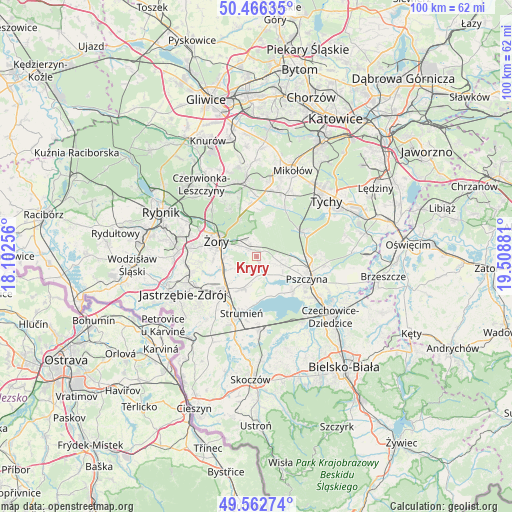
Kryry GPS coordinates[2]
50° 1' 0.012" North, 18° 48' 20.448" East
| Map corner | latitude | longitude |
|---|---|---|
| Upper-left | 50.46635°, | 18.10256° |
| Center: | 50.01667°, | 18.80568° |
| Lower-right: | 49.56274°, | 19.50881° |
| Map W x H: | 100.5×100.5 km | = 62.4×62.4mi |
| max Lat: | 54.83135° ⇑81.6% North |
| Kryry: | 50.01667° |
| min Lat: | ⇓18.4% South 49.21328° |
| min Long | Kryry | max Long |
| 14.20249° | 18.80568° | 24.03723° |
| W 36.8%⇐ | ⇒63.2% E |
Elevation
Elevation of Kryry is 267 m = 876 ft, and this is 75.6 m = 248 ft above average elevation for this country.
| Max E: |
974 m = 3196 ft | 19.7% |
| Kryry | 267 m 876 ft | |
| Avg. | 191.4 m = 628 ft | |
Min E: |
-3 m = -10 ft | 80.3% |
See also: Poland elevation on elevation.city.
Geographical zone
Kryry is located in North temperate zone (between Tropic of Cancer and the Arctic Circle). Distance of this North polar circle is 1839.8 km =1143.2 mi to North.| Distance of | km | miles | from Kryry |
|---|---|---|---|
| North Pole | 4445.7 | 2762.4 | to North |
| Arctic Circle | 1839.8 | 1143.2 | to North |
| Tropic Cancer | 2955.4 | 1836.4 | to South |
| Equator | 5561.3 | 3455.6 | to South |


Nearby cities:
15 places around Kryry: (largest is in red/bold)
• Czarków
7.2 km =4.5 mi,  88°
88°
• Gardawice
11.1 km =6.9 mi,  357°
357°
• Gostyń
11.3 km =7 mi,  29°
29°
• Kobiór
10.4 km =6.5 mi,  61°
61°
• Krzyżowice
10.1 km =6.3 mi,  249°
249°
• Pawłowice
8.8 km =5.5 mi,  225°
225°
• Piasek
10.2 km =6.3 mi, 93°
• Pszczyna
11.3 km =7 mi,  110°
110°
• Radostowice
5.6 km =3.5 mi, 105°
• Rudziczka
3.8 km =2.4 mi,  304°
304°
• Strumień
11 km =6.8 mi,  194°
194°
• Studzionka
6.5 km =4 mi,  201°
201°
• Suszec
1.8 km =1.1 mi,  324°
324°
• Zbytków
11.9 km =7.4 mi,  208°
208°
• Żory
8.1 km =5 mi,  292°
292°
Sources, notices
• [Note1] Compared only with cities in Poland existing in our database
• [Src1] Map data: © OpenStreetMap contributors (CC-BY-SA)
• [Src2] Other city data from geonames.org with taken over terms of usage.
• [Src3] Geographical zone / Annual Mean Temperature by Robert A. Rohde @ Wikipedia
