Radostowice geodata
Radostowice (Silesia) is a populated place; located in Poland in Europe/Warsaw (GMT+2) time zone. With population of 1,559 people, there are 1797 cities with bigger population in this country. Compared to other cities in Poland, 82.4% of cities are located further ↑North; 62.3% of cities are located further →East and 80.3% of cities have lower elevation than Radostowice. Note1


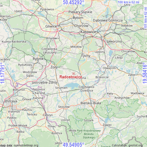
Radostowice GPS coordinates[2]
50° 0' 11.196" North, 18° 52' 51.708" East
| Map corner | latitude | longitude |
|---|---|---|
| Upper-left | 50.45292°, | 18.17791° |
| Center: | 50.00311°, | 18.88103° |
| Lower-right: | 49.54905°, | 19.58416° |
| Map W x H: | 100.5×100.5 km | = 62.4×62.4mi |
| max Lat: | 54.83135° ⇑82.4% North |
| Radostowice: | 50.00311° |
| min Lat: | ⇓17.6% South 49.21328° |
| min Long | Radostowice | max Long |
| 14.20249° | 18.88103° | 24.03723° |
| W 37.7%⇐ | ⇒62.3% E |
Elevation
Elevation of Radostowice is 267 m = 876 ft, and this is 75.6 m = 248 ft above average elevation for this country.
| Max E: |
974 m = 3196 ft | 19.7% |
| Radostowice | 267 m 876 ft | |
| Avg. | 191.4 m = 628 ft | |
Min E: |
-3 m = -10 ft | 80.3% |
See also: Poland elevation on elevation.city.
Geographical zone
Radostowice is located in North temperate zone (between Tropic of Cancer and the Arctic Circle). Distance of this North polar circle is 1841.3 km =1144.1 mi to North.| Distance of | km | miles | from Radostowice |
|---|---|---|---|
| North Pole | 4447.2 | 2763.4 | to North |
| Arctic Circle | 1841.3 | 1144.1 | to North |
| Tropic Cancer | 2953.9 | 1835.5 | to South |
| Equator | 5559.8 | 3454.7 | to South |


Nearby cities:
15 places around Radostowice: (largest is in red/bold)
• Chybie
11.8 km =7.3 mi,  198°
198°
• Czarków
2.5 km =1.6 mi,  47°
47°
• Frelichów
11.6 km =7.2 mi,  205°
205°
• Goczałkowice Zdrój
9.1 km =5.7 mi,  135°
135°
• Gostyń
11.4 km =7.1 mi,  0°
0°
• Jankowice
7.7 km =4.8 mi,  91°
91°
• Kobiór
7.5 km =4.7 mi,  30°
30°
• Kryry
5.6 km =3.5 mi,  285°
285°
• Miedźna
12.2 km =7.6 mi,  100°
100°
• Piasek
4.9 km =3 mi,  80°
80°
• Pszczyna
5.8 km =3.6 mi,  115°
115°
• Rudziczka
9.2 km =5.7 mi, 293°
• Studzionka
9 km =5.6 mi,  239°
239°
• Suszec
7 km =4.3 mi, 294°
• Zabrzeg
10.6 km =6.6 mi,  155°
155°
Sources, notices
• [Note1] Compared only with cities in Poland existing in our database
• [Src1] Map data: © OpenStreetMap contributors (CC-BY-SA)
• [Src2] Other city data from geonames.org with taken over terms of usage.
• [Src3] Geographical zone / Annual Mean Temperature by Robert A. Rohde @ Wikipedia
