Stepnica geodata
Stepnica (West Pomerania) is a seat of a third-order administrative division; located in Poland in Europe/Warsaw (GMT+2) time zone. With population of 2,067 people, there are 1444 cities with bigger population in this country. Compared to other cities in Poland, 91% of cities are located further ↓South; 99.4% of cities are located further →East and 99.8% of cities have higher elevation than Stepnica. Note1


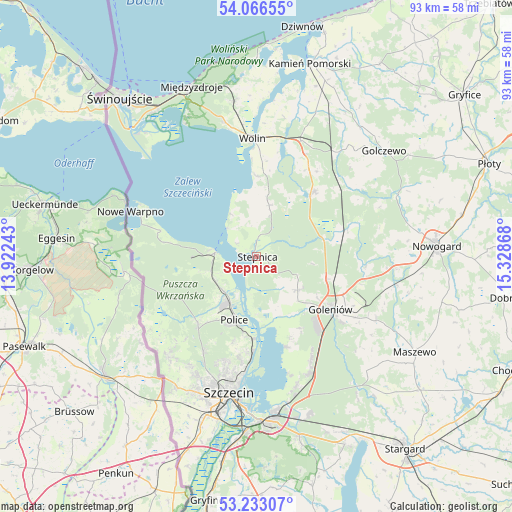
Stepnica GPS coordinates[2]
53° 39' 6.732" North, 14° 37' 31.98" East
| Map corner | latitude | longitude |
|---|---|---|
| Upper-left | 54.06655°, | 13.92243° |
| Center: | 53.65187°, | 14.62555° |
| Lower-right: | 53.23307°, | 15.32868° |
| Map W x H: | 92.7×92.7 km | = 57.6×57.6mi |
| max Lat: | 54.83135° ⇑9% North |
| Stepnica: | 53.65187° |
| min Lat: | ⇓91% South 49.21328° |
| min Long | Stepnica | max Long |
| 14.20249° | 14.62555° | 24.03723° |
| W 0.6%⇐ | ⇒99.4% E |
Elevation
Elevation of Stepnica is 1 m = 3 ft, and this is 190.4 m = 625 ft below average elevation for this country.
| Max E: |
974 m = 3196 ft | 99.8% |
| Avg. | 191.4 m = 628 ft | |
| Stepnica | 1 m = 3 ft | |
Min E: |
-3 m = -10 ft | 0.2% |
See also: Poland elevation on elevation.city.
Geographical zone
Stepnica is located in North temperate zone (between Tropic of Cancer and the Arctic Circle). Distance of this North polar circle is 1435.6 km =892 mi to North.| Distance of | km | miles | from Stepnica |
|---|---|---|---|
| North Pole | 4041.5 | 2511.3 | to North |
| Arctic Circle | 1435.6 | 892 | to North |
| Tropic Cancer | 3359.6 | 2087.6 | to South |
| Equator | 5965.5 | 3706.8 | to South |


Nearby cities:
15 places around Stepnica: (largest is in red/bold)
• Czarnogłowy
22.7 km =14.1 mi,  55°
55°
• Dobra
24.1 km =15 mi,  221°
221°
• Golczewo
30.1 km =18.7 mi,  50°
50°
• Goleniów
16.6 km =10.3 mi,  126°
126°
• Maszewo
33.6 km =20.9 mi,  121°
121°
• Międzyzdroje
32.9 km =20.4 mi,  339°
339°
• Mosty
24.7 km =15.3 mi, 117°
• Nowe Warpno
23.5 km =14.6 mi,  289°
289°
• Nowogard
32.4 km =20.1 mi,  85°
85°
• Osina
26 km =16.2 mi,  101°
101°
• Police
11.6 km =7.2 mi,  197°
197°
• Przecław
32.5 km =20.2 mi, 198°
• Przybiernów
15.8 km =9.8 mi,  41°
41°
• Szczecin
25.2 km =15.7 mi,  190°
190°
• Wolin
21.2 km =13.2 mi,  358°
358°
Sources, notices
• [Note1] Compared only with cities in Poland existing in our database
• [Src1] Map data: © OpenStreetMap contributors (CC-BY-SA)
• [Src2] Other city data from geonames.org with taken over terms of usage.
• [Src3] Geographical zone / Annual Mean Temperature by Robert A. Rohde @ Wikipedia
