Przecław geodata
Przecław (West Pomerania) is a populated place; located in Poland in Europe/Warsaw (GMT+2) time zone. With population of 3,362 people, there are 952 cities with bigger population in this country. Compared to other cities in Poland, 88.2% of cities are located further ↓South; 99.7% of cities are located further →East and 96.2% of cities have higher elevation than Przecław. Note1


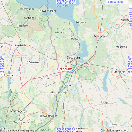
Przecław GPS coordinates[2]
53° 22' 28.092" North, 14° 28' 21.036" East
| Map corner | latitude | longitude |
|---|---|---|
| Upper-left | 53.79188°, | 13.76939° |
| Center: | 53.37447°, | 14.47251° |
| Lower-right: | 52.95293°, | 15.17564° |
| Map W x H: | 93.3×93.3 km | = 58×58mi |
| max Lat: | 54.83135° ⇑11.8% North |
| Przecław: | 53.37447° |
| min Lat: | ⇓88.2% South 49.21328° |
| min Long | Przecław | max Long |
| 14.20249° | 14.47251° | 24.03723° |
| W 0.3%⇐ | ⇒99.7% E |
Elevation
Elevation of Przecław is 30 m = 98 ft, and this is 161.4 m = 530 ft below average elevation for this country.
| Max E: |
974 m = 3196 ft | 96.2% |
| Avg. | 191.4 m = 628 ft | |
| Przecław | 30 m = 98 ft | |
Min E: |
-3 m = -10 ft | 3.8% |
See also: Poland elevation on elevation.city.
Geographical zone
Przecław is located in North temperate zone (between Tropic of Cancer and the Arctic Circle). Distance of this North polar circle is 1466.5 km =911.2 mi to North.| Distance of | km | miles | from Przecław |
|---|---|---|---|
| North Pole | 4072.4 | 2530.5 | to North |
| Arctic Circle | 1466.5 | 911.2 | to North |
| Tropic Cancer | 3328.8 | 2068.4 | to South |
| Equator | 5934.7 | 3687.7 | to South |


Nearby cities:
15 places around Przecław: (largest is in red/bold)
• Banie
33 km =20.5 mi,  157°
157°
• Bielice
25.7 km =16 mi,  138°
138°
• Dobra
13.9 km =8.6 mi,  335°
335°
• Goleniów
31.6 km =19.6 mi,  48°
48°
• Gryfino
13.6 km =8.5 mi,  175°
175°
• Kobylanka
26.7 km =16.6 mi,  97°
97°
• Kołbaskowo
4.8 km =3 mi,  208°
208°
• Lubanowo
28.7 km =17.8 mi, 161°
• Morzyczyn
29.7 km =18.5 mi,  94°
94°
• Police
20.8 km =12.9 mi,  18°
18°
• Stare Czarnowo
23 km =14.3 mi,  117°
117°
• Stepnica
32.5 km =20.2 mi, 18°
• Szczecin
8.1 km =5 mi,  41°
41°
• Warnice
37.2 km =23.1 mi,  111°
111°
• Widuchowa
28.1 km =17.5 mi,  191°
191°
Sources, notices
• [Note1] Compared only with cities in Poland existing in our database
• [Src1] Map data: © OpenStreetMap contributors (CC-BY-SA)
• [Src2] Other city data from geonames.org with taken over terms of usage.
• [Src3] Geographical zone / Annual Mean Temperature by Robert A. Rohde @ Wikipedia
