Maszewo geodata
Maszewo (West Pomerania) is a seat of a third-order administrative division; located in Poland in Europe/Warsaw (GMT+2) time zone. With population of 3,231 people, there are 981 cities with bigger population in this country. Compared to other cities in Poland, 89.5% of cities are located further ↓South; 97.6% of cities are located further →East and 91.5% of cities have higher elevation than Maszewo. Note1


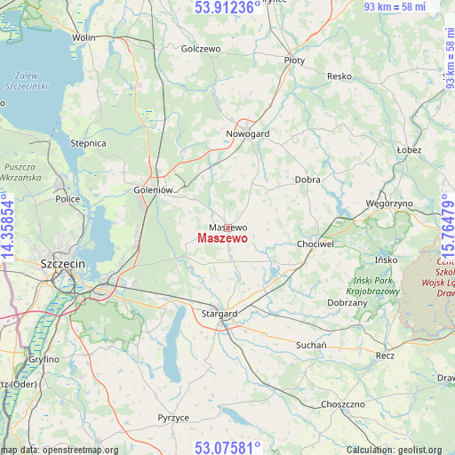
Maszewo GPS coordinates[2]
53° 29' 46.14" North, 15° 3' 41.976" East
| Map corner | latitude | longitude |
|---|---|---|
| Upper-left | 53.91236°, | 14.35854° |
| Center: | 53.49615°, | 15.06166° |
| Lower-right: | 53.07581°, | 15.76479° |
| Map W x H: | 93×93 km | = 57.8×57.8mi |
| max Lat: | 54.83135° ⇑10.5% North |
| Maszewo: | 53.49615° |
| min Lat: | ⇓89.5% South 49.21328° |
| min Long | Maszewo | max Long |
| 14.20249° | 15.06166° | 24.03723° |
| W 2.4%⇐ | ⇒97.6% E |
Elevation
Elevation of Maszewo is 68 m = 223 ft, and this is 123.4 m = 405 ft below average elevation for this country.
| Max E: |
974 m = 3196 ft | 91.5% |
| Avg. | 191.4 m = 628 ft | |
| Maszewo | 68 m = 223 ft | |
Min E: |
-3 m = -10 ft | 8.5% |
See also: Poland elevation on elevation.city.
Geographical zone
Maszewo is located in North temperate zone (between Tropic of Cancer and the Arctic Circle). Distance of this North polar circle is 1453 km =902.9 mi to North.| Distance of | km | miles | from Maszewo |
|---|---|---|---|
| North Pole | 4058.8 | 2522 | to North |
| Arctic Circle | 1453 | 902.9 | to North |
| Tropic Cancer | 3342.3 | 2076.8 | to South |
| Equator | 5948.2 | 3696 | to South |


Nearby cities:
15 places around Maszewo: (largest is in red/bold)
• Chociwel
18.3 km =11.4 mi,  100°
100°
• Dobra
19.2 km =11.9 mi,  58°
58°
• Dobrzany
28.7 km =17.8 mi,  122°
122°
• Goleniów
17.2 km =10.7 mi,  296°
296°
• Kobylanka
21 km =13 mi,  216°
216°
• Marianowo
18.5 km =11.5 mi,  132°
132°
• Morzyczyn
18.5 km =11.5 mi,  210°
210°
• Mosty
9 km =5.6 mi,  309°
309°
• Nowogard
20.1 km =12.5 mi,  10°
10°
• Osina
12.5 km =7.8 mi,  344°
344°
• Stara Dąbrowa
9.9 km =6.2 mi,  146°
146°
• Stare Czarnowo
30.6 km =19 mi, 217°
• Stargard
17.7 km =11 mi,  182°
182°
• Suchań
29.7 km =18.5 mi,  143°
143°
• Warnice
27.3 km =17 mi,  189°
189°
Sources, notices
• [Note1] Compared only with cities in Poland existing in our database
• [Src1] Map data: © OpenStreetMap contributors (CC-BY-SA)
• [Src2] Other city data from geonames.org with taken over terms of usage.
• [Src3] Geographical zone / Annual Mean Temperature by Robert A. Rohde @ Wikipedia
