Nowogard geodata
Nowogard (West Pomerania) is a seat of a third-order administrative division; located in Poland in Europe/Warsaw (GMT+2) time zone. With population of 16,703 people, there are 298 cities with bigger population in this country. Compared to other cities in Poland, 91.2% of cities are located further ↓South; 97.2% of cities are located further →East and 94.1% of cities have higher elevation than Nowogard. Note1


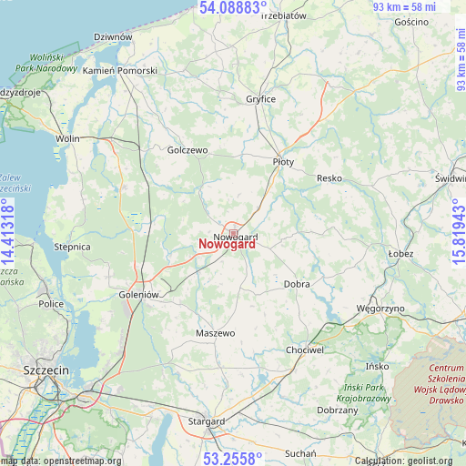
Nowogard GPS coordinates[2]
53° 40' 27.732" North, 15° 6' 58.68" East
| Map corner | latitude | longitude |
|---|---|---|
| Upper-left | 54.08883°, | 14.41318° |
| Center: | 53.67437°, | 15.1163° |
| Lower-right: | 53.2558°, | 15.81943° |
| Map W x H: | 92.6×92.6 km | = 57.5×57.5mi |
| max Lat: | 54.83135° ⇑8.8% North |
| Nowogard: | 53.67437° |
| min Lat: | ⇓91.2% South 49.21328° |
| min Long | Nowogard | max Long |
| 14.20249° | 15.1163° | 24.03723° |
| W 2.8%⇐ | ⇒97.2% E |
Elevation
Elevation of Nowogard is 52 m = 171 ft, and this is 139.4 m = 457 ft below average elevation for this country.
| Max E: |
974 m = 3196 ft | 94.1% |
| Avg. | 191.4 m = 628 ft | |
| Nowogard | 52 m = 171 ft | |
Min E: |
-3 m = -10 ft | 5.9% |
See also: Poland elevation on elevation.city.
Geographical zone
Nowogard is located in North temperate zone (between Tropic of Cancer and the Arctic Circle). Distance of this North polar circle is 1433.1 km =890.5 mi to North.| Distance of | km | miles | from Nowogard |
|---|---|---|---|
| North Pole | 4039 | 2509.7 | to North |
| Arctic Circle | 1433.1 | 890.5 | to North |
| Tropic Cancer | 3362.1 | 2089.1 | to South |
| Equator | 5968 | 3708.3 | to South |


Nearby cities:
15 places around Nowogard: (largest is in red/bold)
• Chociwel
27.2 km =16.9 mi,  148°
148°
• Czarnogłowy
17.1 km =10.6 mi,  307°
307°
• Dobra
16.1 km =10 mi,  127°
127°
• Golczewo
19 km =11.8 mi,  331°
331°
• Goleniów
22.6 km =14 mi,  237°
237°
• Gryfice
27.5 km =17.1 mi,  11°
11°
• Maszewo
20.1 km =12.5 mi,  190°
190°
• Mosty
17.6 km =10.9 mi,  216°
216°
• Osina
10.3 km =6.4 mi, 221°
• Przybiernów
23.7 km =14.7 mi,  293°
293°
• Płoty
17.3 km =10.7 mi,  34°
34°
• Radowo Małe
21.9 km =13.6 mi,  92°
92°
• Resko
22 km =13.7 mi,  60°
60°
• Stara Dąbrowa
28.1 km =17.5 mi,  176°
176°
• Stepnica
32.4 km =20.1 mi,  265°
265°
Sources, notices
• [Note1] Compared only with cities in Poland existing in our database
• [Src1] Map data: © OpenStreetMap contributors (CC-BY-SA)
• [Src2] Other city data from geonames.org with taken over terms of usage.
• [Src3] Geographical zone / Annual Mean Temperature by Robert A. Rohde @ Wikipedia
