Stare Polichno geodata
Stare Polichno (Lubusz) is a populated place; located in Poland in Europe/Warsaw (GMT+2) time zone. With population of 713 people, there are 3044 cities with bigger population in this country. Compared to other cities in Poland, 79.6% of cities are located further ↓South; 95.7% of cities are located further →East and 96.8% of cities have higher elevation than Stare Polichno. Note1


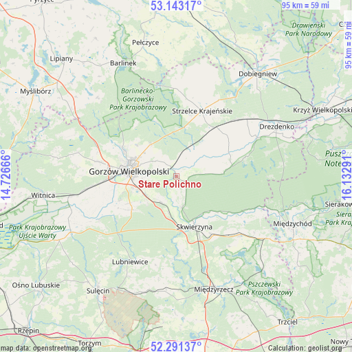
Stare Polichno GPS coordinates[2]
52° 43' 9.66" North, 15° 25' 47.208" East
| Map corner | latitude | longitude |
|---|---|---|
| Upper-left | 53.14317°, | 14.72666° |
| Center: | 52.71935°, | 15.42978° |
| Lower-right: | 52.29137°, | 16.13291° |
| Map W x H: | 94.7×94.7 km | = 58.8×58.8mi |
| max Lat: | 54.83135° ⇑20.4% North |
| Stare Polichno: | 52.71935° |
| min Lat: | ⇓79.6% South 49.21328° |
| min Long | Stare Polichno | max Long |
| 14.20249° | 15.42978° | 24.03723° |
| W 4.3%⇐ | ⇒95.7% E |
Elevation
Elevation of Stare Polichno is 23 m = 75 ft, and this is 168.4 m = 552 ft below average elevation for this country.
| Max E: |
974 m = 3196 ft | 96.8% |
| Avg. | 191.4 m = 628 ft | |
| Stare Polichno | 23 m = 75 ft | |
Min E: |
-3 m = -10 ft | 3.2% |
See also: Poland elevation on elevation.city.
Geographical zone
Stare Polichno is located in North temperate zone (between Tropic of Cancer and the Arctic Circle). Distance of this North polar circle is 1539.3 km =956.5 mi to North.| Distance of | km | miles | from Stare Polichno |
|---|---|---|---|
| North Pole | 4145.2 | 2575.7 | to North |
| Arctic Circle | 1539.3 | 956.5 | to North |
| Tropic Cancer | 3255.9 | 2023.1 | to South |
| Equator | 5861.8 | 3642.4 | to South |


Nearby cities:
15 places around Stare Polichno: (largest is in red/bold)
• Baczyna
21.6 km =13.4 mi,  280°
280°
• Bledzew
22.5 km =14 mi,  182°
182°
• Deszczno
9.2 km =5.7 mi,  233°
233°
• Gorzów Wielkopolski
13.7 km =8.5 mi, 278°
• Gralewo
4.6 km =2.9 mi,  318°
318°
• Jenin
22.5 km =14 mi,  263°
263°
• Kłodawa
16.3 km =10.1 mi,  297°
297°
• Przytoczna
23 km =14.3 mi,  133°
133°
• Santok
2.4 km =1.5 mi,  327°
327°
• Skwierzyna
14.3 km =8.9 mi,  158°
158°
• Stare Kurowo
22.6 km =14 mi,  47°
47°
• Strzelce Krajeńskie
18.8 km =11.7 mi,  20°
20°
• Trzebiszewo
10.4 km =6.5 mi,  191°
191°
• Zwierzyń
15.6 km =9.7 mi,  36°
36°
• Łupowo
20.9 km =13 mi, 264°
Sources, notices
• [Note1] Compared only with cities in Poland existing in our database
• [Src1] Map data: © OpenStreetMap contributors (CC-BY-SA)
• [Src2] Other city data from geonames.org with taken over terms of usage.
• [Src3] Geographical zone / Annual Mean Temperature by Robert A. Rohde @ Wikipedia
