Deszczno geodata
Deszczno (Lubusz) is a seat of a third-order administrative division; located in Poland in Europe/Warsaw (GMT+2) time zone. With population of 1,100 people, there are 2307 cities with bigger population in this country. Compared to other cities in Poland, 78.8% of cities are located further ↓South; 96.4% of cities are located further →East and 97.2% of cities have higher elevation than Deszczno. Note1


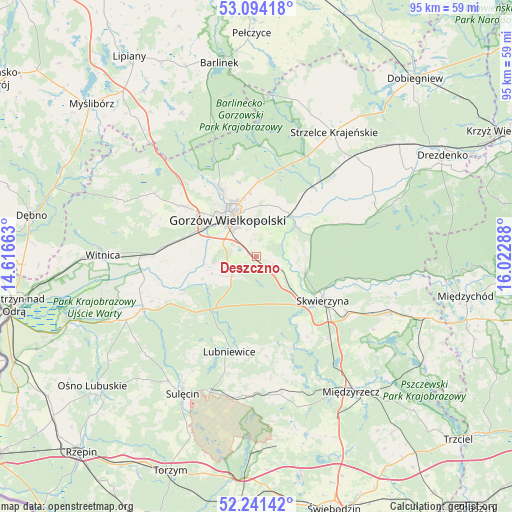
Deszczno GPS coordinates[2]
52° 40' 11.568" North, 15° 19' 11.1" East
| Map corner | latitude | longitude |
|---|---|---|
| Upper-left | 53.09418°, | 14.61663° |
| Center: | 52.66988°, | 15.31975° |
| Lower-right: | 52.24142°, | 16.02288° |
| Map W x H: | 94.8×94.8 km | = 58.9×58.9mi |
| max Lat: | 54.83135° ⇑21.2% North |
| Deszczno: | 52.66988° |
| min Lat: | ⇓78.8% South 49.21328° |
| min Long | Deszczno | max Long |
| 14.20249° | 15.31975° | 24.03723° |
| W 3.6%⇐ | ⇒96.4% E |
Elevation
Elevation of Deszczno is 20 m = 66 ft, and this is 171.4 m = 562 ft below average elevation for this country.
| Max E: |
974 m = 3196 ft | 97.2% |
| Avg. | 191.4 m = 628 ft | |
| Deszczno | 20 m = 66 ft | |
Min E: |
-3 m = -10 ft | 2.8% |
See also: Poland elevation on elevation.city.
Geographical zone
Deszczno is located in North temperate zone (between Tropic of Cancer and the Arctic Circle). Distance of this North polar circle is 1544.8 km =959.9 mi to North.| Distance of | km | miles | from Deszczno |
|---|---|---|---|
| North Pole | 4150.7 | 2579.1 | to North |
| Arctic Circle | 1544.8 | 959.9 | to North |
| Tropic Cancer | 3250.4 | 2019.7 | to South |
| Equator | 5856.3 | 3638.9 | to South |


Nearby cities:
15 places around Deszczno: (largest is in red/bold)
• Baczyna
16.7 km =10.4 mi,  304°
304°
• Bledzew
18.1 km =11.2 mi,  159°
159°
• Bogdaniec
16.9 km =10.5 mi,  277°
277°
• Glisno
22.2 km =13.8 mi,  193°
193°
• Gorzów Wielkopolski
9.6 km =6 mi,  320°
320°
• Gralewo
10 km =6.2 mi,  26°
26°
• Jenin
15.2 km =9.4 mi, 281°
• Kłodawa
14.7 km =9.1 mi,  331°
331°
• Lubniewice
17.7 km =11 mi,  195°
195°
• Santok
9.7 km =6 mi,  38°
38°
• Skwierzyna
14.9 km =9.3 mi,  121°
121°
• Stare Polichno
9.2 km =5.7 mi,  53°
53°
• Trzebiszewo
7.2 km =4.5 mi,  130°
130°
• Wysoka
22.4 km =13.9 mi, 302°
• Łupowo
13.9 km =8.6 mi,  285°
285°
Sources, notices
• [Note1] Compared only with cities in Poland existing in our database
• [Src1] Map data: © OpenStreetMap contributors (CC-BY-SA)
• [Src2] Other city data from geonames.org with taken over terms of usage.
• [Src3] Geographical zone / Annual Mean Temperature by Robert A. Rohde @ Wikipedia
