Baczyna geodata
Baczyna (Lubusz) is a populated place; located in Poland in Europe/Warsaw (GMT+2) time zone. With population of 900 people, there are 2674 cities with bigger population in this country. Compared to other cities in Poland, 80.2% of cities are located further ↓South; 97.2% of cities are located further →East and 78.4% of cities have higher elevation than Baczyna. Note1
Administrative division(s):
- Level 1: Lubusz
- Level 2: Gorzów Wielkopolski
- Level 3: Gorzów Wielkopolski


Baczyna GPS coordinates[2]
52° 45' 18" North, 15° 6' 54.468" East
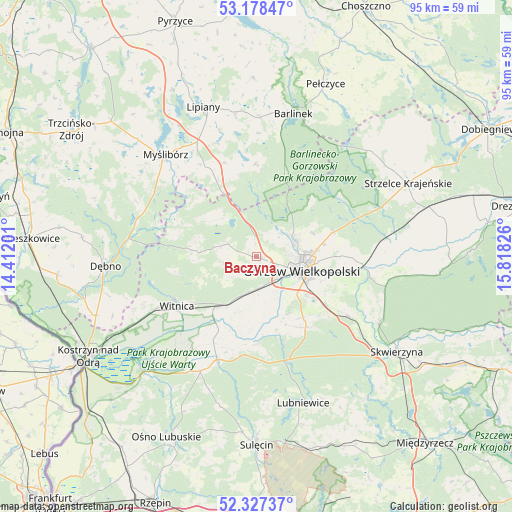
| Map corner | latitude | longitude |
|---|---|---|
| Upper-left | 53.17847°, | 14.41201° |
| Center: | 52.755°, | 15.11513° |
| Lower-right: | 52.32737°, | 15.81826° |
| Map W x H: | 94.6×94.6 km | = 58.8×58.8mi |
| max Lat: | 54.83135° ⇑19.8% North |
| Baczyna: | 52.755° |
| min Lat: | ⇓80.2% South 49.21328° |
| min Long | Baczyna | max Long |
| 14.20249° | 15.11513° | 24.03723° |
| W 2.8%⇐ | ⇒97.2% E |
Elevation
Elevation of Baczyna is 103 m = 338 ft, and this is 88.4 m = 290 ft below average elevation for this country.
| Max E: |
974 m = 3196 ft | 78.4% |
| Avg. | 191.4 m = 628 ft | |
| Baczyna | 103 m = 338 ft | |
Min E: |
-3 m = -10 ft | 21.6% |
See also: Poland elevation on elevation.city.
Geographical zone
Baczyna is located in North temperate zone (between Tropic of Cancer and the Arctic Circle). Distance of this North polar circle is 1535.4 km =954.1 mi to North.| Distance of | km | miles | from Baczyna |
|---|---|---|---|
| North Pole | 4141.3 | 2573.3 | to North |
| Arctic Circle | 1535.4 | 954.1 | to North |
| Tropic Cancer | 3259.9 | 2025.6 | to South |
| Equator | 5865.8 | 3644.8 | to South |


Nearby cities:
15 places around Baczyna: (largest is in red/bold)
• Bogdaniec
7.9 km =4.9 mi,  201°
201°
• Deszczno
16.7 km =10.4 mi,  124°
124°
• Gorzów Wielkopolski
7.9 km =4.9 mi,  104°
104°
• Gralewo
18.2 km =11.3 mi,  91°
91°
• Jenin
6.6 km =4.1 mi,  190°
190°
• Krzeszyce
20.4 km =12.7 mi, 200°
• Kłodawa
7.5 km =4.7 mi,  62°
62°
• Lubiszyn
11.6 km =7.2 mi,  284°
284°
• Nowogródek Pomorski
18.3 km =11.4 mi,  341°
341°
• Santok
20 km =12.4 mi, 95°
• Stare Polichno
21.6 km =13.4 mi, 100°
• Trzcinna
15.8 km =9.8 mi,  333°
333°
• Witnica
17.2 km =10.7 mi,  238°
238°
• Wysoka
5.7 km =3.5 mi,  295°
295°
• Łupowo
5.9 km =3.7 mi,  176°
176°
Sources, notices
• [Note1] Compared only with cities in Poland existing in our database
• [Src1] Map data: © OpenStreetMap contributors (CC-BY-SA)
• [Src2] Other city data from geonames.org with taken over terms of usage.
• [Src3] Geographical zone / Annual Mean Temperature by Robert A. Rohde @ Wikipedia
