Przytoczna geodata
Przytoczna (Lubusz) is a seat of a third-order administrative division; located in Poland in Europe/Warsaw (GMT+2) time zone. With population of 2,400 people, there are 1283 cities with bigger population in this country. Compared to other cities in Poland, 77.6% of cities are located further ↓South; 94.4% of cities are located further →East and 94% of cities have higher elevation than Przytoczna. Note1


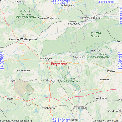
Przytoczna GPS coordinates[2]
52° 34' 39.18" North, 15° 40' 43.608" East
| Map corner | latitude | longitude |
|---|---|---|
| Upper-left | 53.00275°, | 14.97566° |
| Center: | 52.57755°, | 15.67878° |
| Lower-right: | 52.14819°, | 16.38191° |
| Map W x H: | 95×95 km | = 59×59mi |
| max Lat: | 54.83135° ⇑22.4% North |
| Przytoczna: | 52.57755° |
| min Lat: | ⇓77.6% South 49.21328° |
| min Long | Przytoczna | max Long |
| 14.20249° | 15.67878° | 24.03723° |
| W 5.6%⇐ | ⇒94.4% E |
Elevation
Elevation of Przytoczna is 54 m = 177 ft, and this is 137.4 m = 451 ft below average elevation for this country.
| Max E: |
974 m = 3196 ft | 94% |
| Avg. | 191.4 m = 628 ft | |
| Przytoczna | 54 m = 177 ft | |
Min E: |
-3 m = -10 ft | 6% |
See also: Poland elevation on elevation.city.
Geographical zone
Przytoczna is located in North temperate zone (between Tropic of Cancer and the Arctic Circle). Distance of this North polar circle is 1555.1 km =966.3 mi to North.| Distance of | km | miles | from Przytoczna |
|---|---|---|---|
| North Pole | 4161 | 2585.5 | to North |
| Arctic Circle | 1555.1 | 966.3 | to North |
| Tropic Cancer | 3240.2 | 2013.4 | to South |
| Equator | 5846.1 | 3632.6 | to South |


Nearby cities:
15 places around Przytoczna: (largest is in red/bold)
• Bledzew
19.1 km =11.9 mi,  249°
249°
• Brójce
28.9 km =18 mi,  180°
180°
• Deszczno
26.3 km =16.3 mi,  292°
292°
• Gralewo
27.6 km =17.1 mi,  314°
314°
• Kwilcz
27.6 km =17.1 mi,  95°
95°
• Międzychód
14.9 km =9.3 mi,  80°
80°
• Międzyrzecz
16.3 km =10.1 mi,  204°
204°
• Pszczew
13.1 km =8.1 mi,  148°
148°
• Santok
25.4 km =15.8 mi, 314°
• Sieraków
28.3 km =17.6 mi,  73°
73°
• Skwierzyna
11.9 km =7.4 mi,  281°
281°
• Stare Polichno
23 km =14.3 mi, 313°
• Trzciel
27 km =16.8 mi, 150°
• Trzebiszewo
19.6 km =12.2 mi, 286°
• Łowyń
17.7 km =11 mi,  118°
118°
Sources, notices
• [Note1] Compared only with cities in Poland existing in our database
• [Src1] Map data: © OpenStreetMap contributors (CC-BY-SA)
• [Src2] Other city data from geonames.org with taken over terms of usage.
• [Src3] Geographical zone / Annual Mean Temperature by Robert A. Rohde @ Wikipedia
