Gorzów Wielkopolski geodata
Gorzów Wielkopolski (Lubusz) is a seat of a first-order administrative division; located in Poland in Europe/Warsaw (GMT+2) time zone. With population of 124,430 people, there are 37 cities with bigger population in this country. Compared to other cities in Poland, 79.7% of cities are located further ↓South; 96.8% of cities are located further →East and 95.7% of cities have higher elevation than Gorzów Wielkopolski. Note1
Administrative division(s):
- Level 1: Lubusz
- Level 2: Gorzów Wielkopolski
- Level 3: Gorzów Wielkopolski


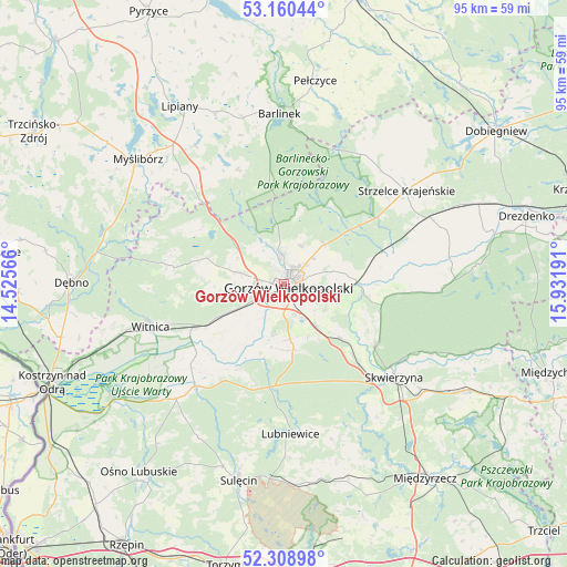
Gorzów Wielkopolski GPS coordinates[2]
52° 44' 12.444" North, 15° 13' 43.608" East
| Map corner | latitude | longitude |
|---|---|---|
| Upper-left | 53.16044°, | 14.52566° |
| Center: | 52.73679°, | 15.22878° |
| Lower-right: | 52.30898°, | 15.93191° |
| Map W x H: | 94.7×94.7 km | = 58.8×58.8mi |
| max Lat: | 54.83135° ⇑20.3% North |
| Gorzów Wielkopolski: | 52.73679° |
| min Lat: | ⇓79.7% South 49.21328° |
| min Long | Gorzów Wielkop | max Long |
| 14.20249° | 15.22878° | 24.03723° |
| W 3.2%⇐ | ⇒96.8% E |
Elevation
Elevation of Gorzów Wielkopolski is 34 m = 112 ft, and this is 157.4 m = 516 ft below average elevation for this country.
| Max E: |
974 m = 3196 ft | 95.7% |
| Avg. | 191.4 m = 628 ft | |
| Gorzów Wielkopolski | 34 m = 112 ft | |
Min E: |
-3 m = -10 ft | 4.3% |
See also: Gorzów Wielkopolski elevation on elevation.city.
Geographical zone
Gorzów Wielkopolski is located in North temperate zone (between Tropic of Cancer and the Arctic Circle). Distance of this North polar circle is 1537.4 km =955.3 mi to North.| Distance of | km | miles | from Gorzów Wielkopolski |
|---|---|---|---|
| North Pole | 4143.3 | 2574.5 | to North |
| Arctic Circle | 1537.4 | 955.3 | to North |
| Tropic Cancer | 3257.9 | 2024.4 | to South |
| Equator | 5863.8 | 3643.6 | to South |


Nearby cities:
15 places around Gorzów Wielkopolski: (largest is in red/bold)
• Baczyna
7.9 km =4.9 mi,  284°
284°
• Bogdaniec
11.9 km =7.4 mi,  243°
243°
• Deszczno
9.6 km =6 mi,  140°
140°
• Gralewo
10.6 km =6.6 mi,  81°
81°
• Jenin
9.9 km =6.2 mi, 243°
• Krzeszyce
22.7 km =14.1 mi,  221°
221°
• Kłodawa
5.5 km =3.4 mi,  350°
350°
• Lubiszyn
19.5 km =12.1 mi, 284°
• Santok
12.2 km =7.6 mi,  89°
89°
• Stare Polichno
13.7 km =8.5 mi,  98°
98°
• Trzcinna
21.8 km =13.5 mi,  317°
317°
• Trzebiszewo
16.8 km =10.4 mi, 136°
• Witnica
23.4 km =14.5 mi,  252°
252°
• Wysoka
13.6 km =8.5 mi,  289°
289°
• Łupowo
8.2 km =5.1 mi, 242°
In other languages:
- In German: Landsberg, Landsberg an der Warthe, Gorzów Wielkopolski
- In Russian: Гожув-Велькопольски, Гожув-Велькопольский
- In Chinese: 大波蘭地區戈茹夫
Sources, notices
• [Note1] Compared only with cities in Poland existing in our database
• [Src1] Map data: © OpenStreetMap contributors (CC-BY-SA)
• [Src2] Other city data from geonames.org with taken over terms of usage.
• [Src3] Geographical zone / Annual Mean Temperature by Robert A. Rohde @ Wikipedia
