Strzelce Krajeńskie geodata
Strzelce Krajeńskie (Lubusz) is a seat of a second-order administrative division; located in Poland in Europe/Warsaw (GMT+2) time zone. With population of 9,978 people, there are 445 cities with bigger population in this country. Compared to other cities in Poland, 82% of cities are located further ↓South; 95.2% of cities are located further →East and 90.2% of cities have higher elevation than Strzelce Krajeńskie. Note1
Administrative division(s):
- Level 1: Lubusz
- Level 2: Powiat strzelecko-drezdenecki
- Level 3: Strzelce Krajeńskie


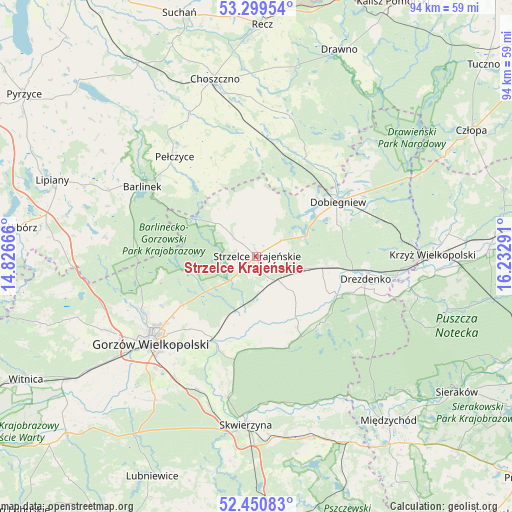
Strzelce Krajeńskie GPS coordinates[2]
52° 52' 38.136" North, 15° 31' 47.208" East
| Map corner | latitude | longitude |
|---|---|---|
| Upper-left | 53.29954°, | 14.82666° |
| Center: | 52.87726°, | 15.52978° |
| Lower-right: | 52.45083°, | 16.23291° |
| Map W x H: | 94.4×94.4 km | = 58.7×58.7mi |
| max Lat: | 54.83135° ⇑18% North |
| Strzelce Krajeńskie: | 52.87726° |
| min Lat: | ⇓82% South 49.21328° |
| min Long | Strzelce Kraje� | max Long |
| 14.20249° | 15.52978° | 24.03723° |
| W 4.8%⇐ | ⇒95.2% E |
Elevation
Elevation of Strzelce Krajeńskie is 75 m = 246 ft, and this is 116.4 m = 382 ft below average elevation for this country.
| Max E: |
974 m = 3196 ft | 90.2% |
| Avg. | 191.4 m = 628 ft | |
| Strzelce Krajeńskie | 75 m = 246 ft | |
Min E: |
-3 m = -10 ft | 9.8% |
See also: Poland elevation on elevation.city.
Geographical zone
Strzelce Krajeńskie is located in North temperate zone (between Tropic of Cancer and the Arctic Circle). Distance of this North polar circle is 1521.8 km =945.6 mi to North.| Distance of | km | miles | from Strzelce Krajeńskie |
|---|---|---|---|
| North Pole | 4127.7 | 2564.8 | to North |
| Arctic Circle | 1521.8 | 945.6 | to North |
| Tropic Cancer | 3273.5 | 2034.1 | to South |
| Equator | 5879.4 | 3653.3 | to South |


Nearby cities:
15 places around Strzelce Krajeńskie: (largest is in red/bold)
• Barlinek
24.6 km =15.3 mi,  302°
302°
• Bierzwnik
19.8 km =12.3 mi,  27°
27°
• Deszczno
27 km =16.8 mi,  211°
211°
• Dobiegniew
18.2 km =11.3 mi,  55°
55°
• Drezdenko
20.7 km =12.9 mi,  102°
102°
• Gorzów Wielkopolski
25.6 km =15.9 mi,  232°
232°
• Gralewo
17.1 km =10.6 mi, 214°
• Krzęcin
22.9 km =14.2 mi,  353°
353°
• Kłodawa
23.5 km =14.6 mi,  244°
244°
• Pełczyce
23.9 km =14.9 mi,  320°
320°
• Santok
17.5 km =10.9 mi, 207°
• Stare Kurowo
10.2 km =6.3 mi, 102°
• Stare Polichno
18.8 km =11.7 mi,  200°
200°
• Trzebiszewo
29.1 km =18.1 mi, 197°
• Zwierzyń
5.6 km =3.5 mi,  153°
153°
Sources, notices
• [Note1] Compared only with cities in Poland existing in our database
• [Src1] Map data: © OpenStreetMap contributors (CC-BY-SA)
• [Src2] Other city data from geonames.org with taken over terms of usage.
• [Src3] Geographical zone / Annual Mean Temperature by Robert A. Rohde @ Wikipedia
