Żory geodata
Żory (Silesia) is a seat of a second-order administrative division; located in Poland in Europe/Warsaw (GMT+2) time zone. With population of 63,174 people, there are 80 cities with bigger population in this country. Compared to other cities in Poland, 80.2% of cities are located further ↑North; 65% of cities are located further →East and 76.3% of cities have lower elevation than Żory. Note1


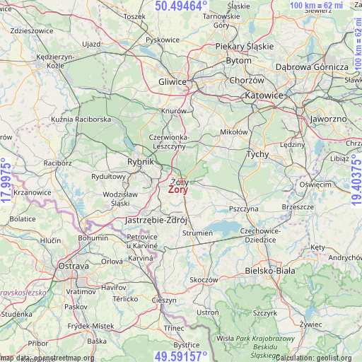
Żory GPS coordinates[2]
50° 2' 42.828" North, 18° 42' 2.232" East
| Map corner | latitude | longitude |
|---|---|---|
| Upper-left | 50.49464°, | 17.9975° |
| Center: | 50.04523°, | 18.70062° |
| Lower-right: | 49.59157°, | 19.40375° |
| Map W x H: | 100.4×100.4 km | = 62.4×62.4mi |
| max Lat: | 54.83135° ⇑80.2% North |
| Żory: | 50.04523° |
| min Lat: | ⇓19.8% South 49.21328° |
| min Long | Żory | max Long |
| 14.20249° | 18.70062° | 24.03723° |
| W 35%⇐ | ⇒65% E |
Elevation
Elevation of Żory is 251 m = 823 ft, and this is 59.6 m = 196 ft above average elevation for this country.
| Max E: |
974 m = 3196 ft | 23.7% |
| Żory | 251 m 823 ft | |
| Avg. | 191.4 m = 628 ft | |
Min E: |
-3 m = -10 ft | 76.3% |
See also: Żory elevation on elevation.city.
Geographical zone
Żory is located in North temperate zone (between Tropic of Cancer and the Arctic Circle). Distance of this North polar circle is 1836.7 km =1141.3 mi to North.| Distance of | km | miles | from Żory |
|---|---|---|---|
| North Pole | 4442.6 | 2760.5 | to North |
| Arctic Circle | 1836.7 | 1141.3 | to North |
| Tropic Cancer | 2958.6 | 1838.4 | to South |
| Equator | 5564.5 | 3457.6 | to South |


Nearby cities:
15 places around Żory: (largest is in red/bold)
• Bełk
9.5 km =5.9 mi,  6°
6°
• Czerwionka-Leszczyny
11.8 km =7.3 mi,  351°
351°
• Gardawice
10.6 km =6.6 mi,  41°
41°
• Gogołowa
10.2 km =6.3 mi,  230°
230°
• Jankowice Rybnickie
11 km =6.8 mi,  269°
269°
• Kryry
8.1 km =5 mi,  112°
112°
• Krzyżowice
7 km =4.3 mi,  196°
196°
• Pawłowice
9.4 km =5.8 mi,  172°
172°
• Połomia
12.2 km =7.6 mi,  240°
240°
• Rudziczka
4.5 km =2.8 mi,  103°
103°
• Stanowice
9.7 km =6 mi, 347°
• Studzionka
10.6 km =6.6 mi,  150°
150°
• Suszec
6.7 km =4.2 mi, 104°
• Świerklany Dolne
9.3 km =5.8 mi,  251°
251°
• Świerklany Górne
8.1 km =5 mi,  256°
256°
Sources, notices
• [Note1] Compared only with cities in Poland existing in our database
• [Src1] Map data: © OpenStreetMap contributors (CC-BY-SA)
• [Src2] Other city data from geonames.org with taken over terms of usage.
• [Src3] Geographical zone / Annual Mean Temperature by Robert A. Rohde @ Wikipedia
