Somonino geodata
Somonino (Pomerania) is a populated place; located in Poland in Europe/Warsaw (GMT+2) time zone. With population of 2,206 people, there are 1358 cities with bigger population in this country. Compared to other cities in Poland, 97.4% of cities are located further ↓South; 72.7% of cities are located further →East and 52.5% of cities have higher elevation than Somonino. Note1


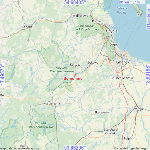
Somonino GPS coordinates[2]
54° 16' 31.98" North, 18° 11' 55.86" East
| Map corner | latitude | longitude |
|---|---|---|
| Upper-left | 54.68405°, | 17.49573° |
| Center: | 54.27555°, | 18.19885° |
| Lower-right: | 53.86296°, | 18.90198° |
| Map W x H: | 91.3×91.3 km | = 56.7×56.7mi |
| max Lat: | 54.83135° ⇑2.6% North |
| Somonino: | 54.27555° |
| min Lat: | ⇓97.4% South 49.21328° |
| min Long | Somonino | max Long |
| 14.20249° | 18.19885° | 24.03723° |
| W 27.3%⇐ | ⇒72.7% E |
Elevation
Elevation of Somonino is 165 m = 541 ft, and this is 26.4 m = 87 ft below average elevation for this country.
| Max E: |
974 m = 3196 ft | 52.5% |
| Avg. | 191.4 m = 628 ft | |
| Somonino | 165 m = 541 ft | |
Min E: |
-3 m = -10 ft | 47.5% |
See also: Poland elevation on elevation.city.
Geographical zone
Somonino is located in North temperate zone (between Tropic of Cancer and the Arctic Circle). Distance of this North polar circle is 1366.3 km =849 mi to North.| Distance of | km | miles | from Somonino |
|---|---|---|---|
| North Pole | 3972.2 | 2468.2 | to North |
| Arctic Circle | 1366.3 | 849 | to North |
| Tropic Cancer | 3429 | 2130.7 | to South |
| Equator | 6034.9 | 3749.9 | to South |


Nearby cities:
15 places around Somonino: (largest is in red/bold)
• Banino
18.7 km =11.6 mi,  46°
46°
• Chmielno
8.5 km =5.3 mi,  310°
310°
• Garcz
10.2 km =6.3 mi,  321°
321°
• Grabowo Kościerskie
12.4 km =7.7 mi,  195°
195°
• Kartuzy
6.5 km =4 mi,  359°
359°
• Kolbudy
17.4 km =10.8 mi,  92°
92°
• Lublewo Gdańskie
19.8 km =12.3 mi, 87°
• Nowa Karczma
15.8 km =9.8 mi,  179°
179°
• Przodkowo
13 km =8.1 mi,  26°
26°
• Przywidz
12 km =7.5 mi,  138°
138°
• Pręgowo
18.4 km =11.4 mi,  97°
97°
• Pępowo
16.2 km =10.1 mi, 48°
• Stężyca
17.6 km =10.9 mi,  243°
243°
• Łapalice
9 km =5.6 mi,  329°
329°
• Żukowo
13.1 km =8.1 mi,  55°
55°
Sources, notices
• [Note1] Compared only with cities in Poland existing in our database
• [Src1] Map data: © OpenStreetMap contributors (CC-BY-SA)
• [Src2] Other city data from geonames.org with taken over terms of usage.
• [Src3] Geographical zone / Annual Mean Temperature by Robert A. Rohde @ Wikipedia
