Garcz geodata
Garcz (Pomerania) is a populated place; located in Poland in Europe/Warsaw (GMT+2) time zone. With population of 1,908 people, there are 1545 cities with bigger population in this country. Compared to other cities in Poland, 98.1% of cities are located further ↓South; 74.1% of cities are located further →East and 51.3% of cities have higher elevation than Garcz. Note1


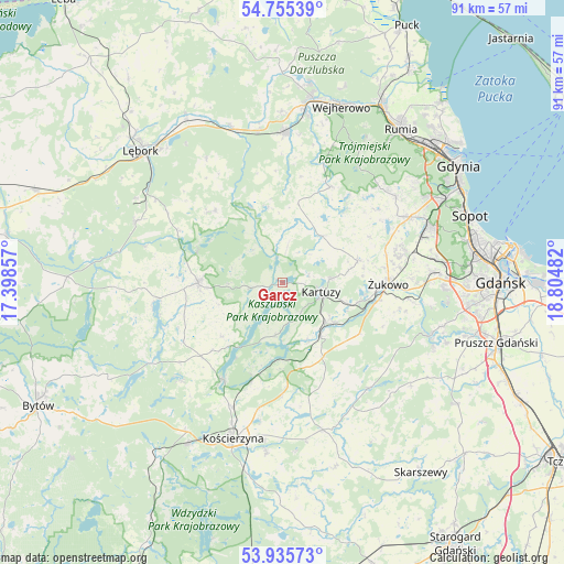
Garcz GPS coordinates[2]
54° 20' 51.36" North, 18° 6' 6.084" East
| Map corner | latitude | longitude |
|---|---|---|
| Upper-left | 54.75539°, | 17.39857° |
| Center: | 54.3476°, | 18.10169° |
| Lower-right: | 53.93573°, | 18.80482° |
| Map W x H: | 91.1×91.1 km | = 56.6×56.6mi |
| max Lat: | 54.83135° ⇑1.9% North |
| Garcz: | 54.3476° |
| min Lat: | ⇓98.1% South 49.21328° |
| min Long | Garcz | max Long |
| 14.20249° | 18.10169° | 24.03723° |
| W 25.9%⇐ | ⇒74.1% E |
Elevation
Elevation of Garcz is 169 m = 554 ft, and this is 22.4 m = 73 ft below average elevation for this country.
| Max E: |
974 m = 3196 ft | 51.3% |
| Avg. | 191.4 m = 628 ft | |
| Garcz | 169 m = 554 ft | |
Min E: |
-3 m = -10 ft | 48.7% |
See also: Poland elevation on elevation.city.
Geographical zone
Garcz is located in North temperate zone (between Tropic of Cancer and the Arctic Circle). Distance of this North polar circle is 1358.3 km =844 mi to North.| Distance of | km | miles | from Garcz |
|---|---|---|---|
| North Pole | 3964.2 | 2463.2 | to North |
| Arctic Circle | 1358.3 | 844 | to North |
| Tropic Cancer | 3437 | 2135.7 | to South |
| Equator | 6042.9 | 3754.9 | to South |


Nearby cities:
15 places around Garcz: (largest is in red/bold)
• Banino
20.3 km =12.6 mi,  75°
75°
• Chmielno
2.5 km =1.6 mi,  184°
184°
• Grabowo Kościerskie
20.2 km =12.6 mi,  171°
171°
• Kartuzy
6.4 km =4 mi,  103°
103°
• Koleczkowo
22 km =13.7 mi,  45°
45°
• Linia
15.8 km =9.8 mi,  316°
316°
• Przodkowo
12.6 km =7.8 mi,  73°
73°
• Przywidz
22.1 km =13.7 mi,  139°
139°
• Pępowo
18.7 km =11.6 mi, 81°
• Sierakowice
13.6 km =8.5 mi,  269°
269°
• Somonino
10.2 km =6.3 mi, 141°
• Stężyca
18.4 km =11.4 mi,  211°
211°
• Szemud
17.4 km =10.8 mi,  26°
26°
• Łapalice
1.8 km =1.1 mi, 96°
• Żukowo
17.1 km =10.6 mi,  92°
92°
Sources, notices
• [Note1] Compared only with cities in Poland existing in our database
• [Src1] Map data: © OpenStreetMap contributors (CC-BY-SA)
• [Src2] Other city data from geonames.org with taken over terms of usage.
• [Src3] Geographical zone / Annual Mean Temperature by Robert A. Rohde @ Wikipedia
