Banino geodata
Banino (Pomerania) is a populated place; located in Poland in Europe/Warsaw (GMT+2) time zone. With population of 2,593 people, there are 1212 cities with bigger population in this country. Compared to other cities in Poland, 98.4% of cities are located further ↓South; 69.5% of cities are located further →East and 63% of cities have higher elevation than Banino. Note1


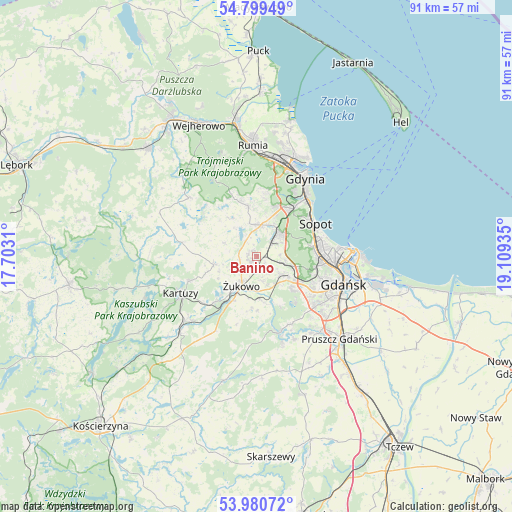
Banino GPS coordinates[2]
54° 23' 31.74" North, 18° 24' 22.392" East
| Map corner | latitude | longitude |
|---|---|---|
| Upper-left | 54.79949°, | 17.7031° |
| Center: | 54.39215°, | 18.40622° |
| Lower-right: | 53.98072°, | 19.10935° |
| Map W x H: | 91×91 km | = 56.5×56.5mi |
| max Lat: | 54.83135° ⇑1.6% North |
| Banino: | 54.39215° |
| min Lat: | ⇓98.4% South 49.21328° |
| min Long | Banino | max Long |
| 14.20249° | 18.40622° | 24.03723° |
| W 30.5%⇐ | ⇒69.5% E |
Elevation
Elevation of Banino is 139 m = 456 ft, and this is 52.4 m = 172 ft below average elevation for this country.
| Max E: |
974 m = 3196 ft | 63% |
| Avg. | 191.4 m = 628 ft | |
| Banino | 139 m = 456 ft | |
Min E: |
-3 m = -10 ft | 37% |
See also: Poland elevation on elevation.city.
Geographical zone
Banino is located in North temperate zone (between Tropic of Cancer and the Arctic Circle). Distance of this North polar circle is 1353.3 km =840.9 mi to North.| Distance of | km | miles | from Banino |
|---|---|---|---|
| North Pole | 3959.2 | 2460.1 | to North |
| Arctic Circle | 1353.3 | 840.9 | to North |
| Tropic Cancer | 3441.9 | 2138.7 | to South |
| Equator | 6047.8 | 3757.9 | to South |


Nearby cities:
15 places around Banino: (largest is in red/bold)
• Bojano
8.9 km =5.5 mi,  350°
350°
• Borkowo Łostowickie
16 km =9.9 mi,  130°
130°
• Chwaszczyno
5.8 km =3.6 mi,  8°
8°
• Kartuzy
15 km =9.3 mi,  244°
244°
• Kolbudy
14.1 km =8.8 mi,  163°
163°
• Koleczkowo
11.2 km =7 mi,  338°
338°
• Kowale
13.6 km =8.5 mi, 132°
• Lublewo Gdańskie
13.5 km =8.4 mi,  152°
152°
• Przodkowo
7.8 km =4.8 mi,  259°
259°
• Pręgowo
16.1 km =10 mi, 162°
• Pępowo
2.6 km =1.6 mi,  208°
208°
• Sopot
11.4 km =7.1 mi,  60°
60°
• Szemud
15.9 km =9.9 mi,  311°
311°
• Wielki Kack
9.9 km =6.2 mi,  32°
32°
• Żukowo
6.2 km =3.9 mi, 205°
Sources, notices
• [Note1] Compared only with cities in Poland existing in our database
• [Src1] Map data: © OpenStreetMap contributors (CC-BY-SA)
• [Src2] Other city data from geonames.org with taken over terms of usage.
• [Src3] Geographical zone / Annual Mean Temperature by Robert A. Rohde @ Wikipedia
