Grabowo Kościerskie geodata
Grabowo Kościerskie (Pomerania) is a populated place; located in Poland in Europe/Warsaw (GMT+2) time zone. With population of 1,159 people, there are 2247 cities with bigger population in this country. Compared to other cities in Poland, 95.9% of cities are located further ↓South; 73.5% of cities are located further →East and 60% of cities have lower elevation than Grabowo Kościerskie. Note1


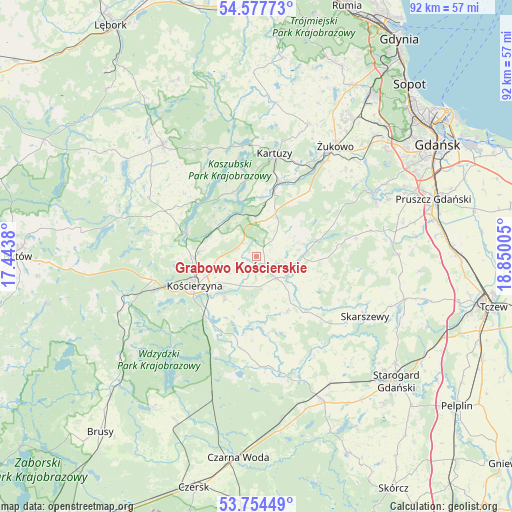
Grabowo Kościerskie GPS coordinates[2]
54° 10' 5.376" North, 18° 8' 48.912" East
| Map corner | latitude | longitude |
|---|---|---|
| Upper-left | 54.57773°, | 17.4438° |
| Center: | 54.16816°, | 18.14692° |
| Lower-right: | 53.75449°, | 18.85005° |
| Map W x H: | 91.5×91.5 km | = 56.9×56.9mi |
| max Lat: | 54.83135° ⇑4.1% North |
| Grabowo Kościerskie: | 54.16816° |
| min Lat: | ⇓95.9% South 49.21328° |
| min Long | Grabowo Koście | max Long |
| 14.20249° | 18.14692° | 24.03723° |
| W 26.5%⇐ | ⇒73.5% E |
Elevation
Elevation of Grabowo Kościerskie is 200 m = 656 ft, and this is 8.6 m = 28 ft above average elevation for this country.
| Max E: |
974 m = 3196 ft | 40% |
| Grabowo Kościerskie | 200 m 656 ft | |
| Avg. | 191.4 m = 628 ft | |
Min E: |
-3 m = -10 ft | 60% |
See also: Poland elevation on elevation.city.
Geographical zone
Grabowo Kościerskie is located in North temperate zone (between Tropic of Cancer and the Arctic Circle). Distance of this North polar circle is 1378.2 km =856.4 mi to North.| Distance of | km | miles | from Grabowo Kościerskie |
|---|---|---|---|
| North Pole | 3984.1 | 2475.6 | to North |
| Arctic Circle | 1378.2 | 856.4 | to North |
| Tropic Cancer | 3417 | 2123.2 | to South |
| Equator | 6022.9 | 3742.5 | to South |


Nearby cities:
15 places around Grabowo Kościerskie: (largest is in red/bold)
• Chmielno
17.8 km =11.1 mi,  349°
349°
• Garcz
20.2 km =12.6 mi, 351°
• Kartuzy
18.8 km =11.7 mi,  10°
10°
• Kolbudy
23.6 km =14.7 mi,  61°
61°
• Kościerzyna
11.9 km =7.4 mi,  244°
244°
• Liniewo
11.4 km =7.1 mi,  152°
152°
• Nowa Karczma
5.3 km =3.3 mi,  137°
137°
• Przywidz
11.7 km =7.3 mi,  75°
75°
• Pręgowo
23.7 km =14.7 mi,  66°
66°
• Skarszewy
22.3 km =13.9 mi,  119°
119°
• Somonino
12.4 km =7.7 mi,  15°
15°
• Stara Kiszewa
19.9 km =12.4 mi,  175°
175°
• Stężyca
13.1 km =8.1 mi,  288°
288°
• Łapalice
19.8 km =12.3 mi,  356°
356°
• Żukowo
24 km =14.9 mi,  36°
36°
Sources, notices
• [Note1] Compared only with cities in Poland existing in our database
• [Src1] Map data: © OpenStreetMap contributors (CC-BY-SA)
• [Src2] Other city data from geonames.org with taken over terms of usage.
• [Src3] Geographical zone / Annual Mean Temperature by Robert A. Rohde @ Wikipedia
