Przodkowo geodata
Przodkowo (Pomerania) is a populated place; located in Poland in Europe/Warsaw (GMT+2) time zone. With population of 1,286 people, there are 2101 cities with bigger population in this country. Compared to other cities in Poland, 98.3% of cities are located further ↓South; 71.5% of cities are located further →East and 52% of cities have lower elevation than Przodkowo. Note1


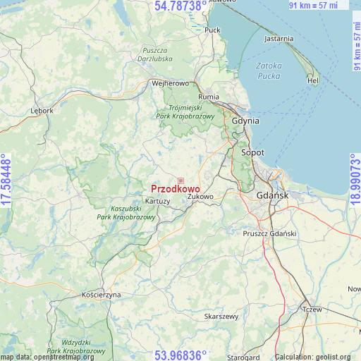
Przodkowo GPS coordinates[2]
54° 22' 47.676" North, 18° 17' 15.36" East
| Map corner | latitude | longitude |
|---|---|---|
| Upper-left | 54.78738°, | 17.58448° |
| Center: | 54.37991°, | 18.2876° |
| Lower-right: | 53.96836°, | 18.99073° |
| Map W x H: | 91.1×91.1 km | = 56.6×56.6mi |
| max Lat: | 54.83135° ⇑1.7% North |
| Przodkowo: | 54.37991° |
| min Lat: | ⇓98.3% South 49.21328° |
| min Long | Przodkowo | max Long |
| 14.20249° | 18.2876° | 24.03723° |
| W 28.5%⇐ | ⇒71.5% E |
Elevation
Elevation of Przodkowo is 177 m = 581 ft, and this is 14.4 m = 47 ft below average elevation for this country.
| Max E: |
974 m = 3196 ft | 48% |
| Avg. | 191.4 m = 628 ft | |
| Przodkowo | 177 m = 581 ft | |
Min E: |
-3 m = -10 ft | 52% |
See also: Poland elevation on elevation.city.
Geographical zone
Przodkowo is located in North temperate zone (between Tropic of Cancer and the Arctic Circle). Distance of this North polar circle is 1354.7 km =841.8 mi to North.| Distance of | km | miles | from Przodkowo |
|---|---|---|---|
| North Pole | 3960.6 | 2461 | to North |
| Arctic Circle | 1354.7 | 841.8 | to North |
| Tropic Cancer | 3440.6 | 2137.9 | to South |
| Equator | 6046.5 | 3757.1 | to South |


Nearby cities:
15 places around Przodkowo: (largest is in red/bold)
• Banino
7.8 km =4.8 mi,  79°
79°
• Bojano
11.9 km =7.4 mi,  31°
31°
• Chmielno
13.7 km =8.5 mi,  243°
243°
• Chwaszczyno
11.1 km =6.9 mi,  50°
50°
• Garcz
12.6 km =7.8 mi,  253°
253°
• Kartuzy
7.7 km =4.8 mi,  229°
229°
• Kolbudy
16.9 km =10.5 mi,  136°
136°
• Koleczkowo
12.4 km =7.7 mi,  17°
17°
• Lublewo Gdańskie
17.6 km =10.9 mi,  127°
127°
• Pępowo
6.5 km =4 mi,  98°
98°
• Somonino
13 km =8.1 mi,  206°
206°
• Szemud
12.6 km =7.8 mi,  340°
340°
• Wielki Kack
16.2 km =10.1 mi, 53°
• Łapalice
10.9 km =6.8 mi, 249°
• Żukowo
6.5 km =4 mi, 129°
Sources, notices
• [Note1] Compared only with cities in Poland existing in our database
• [Src1] Map data: © OpenStreetMap contributors (CC-BY-SA)
• [Src2] Other city data from geonames.org with taken over terms of usage.
• [Src3] Geographical zone / Annual Mean Temperature by Robert A. Rohde @ Wikipedia
