Sławków geodata
Sławków (Silesia) is a seat of a third-order administrative division; located in Poland in Europe/Warsaw (GMT+2) time zone. With population of 6,901 people, there are 546 cities with bigger population in this country. Compared to other cities in Poland, 72.1% of cities are located further ↑North; 52.9% of cities are located further →East and 88% of cities have lower elevation than Sławków. Note1


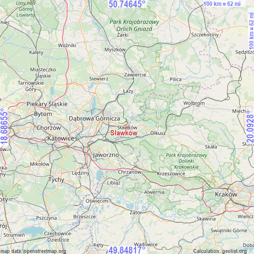
Sławków GPS coordinates[2]
50° 17' 57.948" North, 19° 23' 22.812" East
| Map corner | latitude | longitude |
|---|---|---|
| Upper-left | 50.74645°, | 18.68655° |
| Center: | 50.29943°, | 19.38967° |
| Lower-right: | 49.84817°, | 20.0928° |
| Map W x H: | 99.9×99.9 km | = 62.1×62.1mi |
| max Lat: | 54.83135° ⇑72.1% North |
| Sławków: | 50.29943° |
| min Lat: | ⇓27.9% South 49.21328° |
| min Long | Sławków | max Long |
| 14.20249° | 19.38967° | 24.03723° |
| W 47.1%⇐ | ⇒52.9% E |
Elevation
Elevation of Sławków is 308 m = 1010 ft, and this is 116.6 m = 383 ft above average elevation for this country.
| Max E: |
974 m = 3196 ft | 12% |
| Sławków | 308 m 1010 ft | |
| Avg. | 191.4 m = 628 ft | |
Min E: |
-3 m = -10 ft | 88% |
See also: Poland elevation on elevation.city.
Geographical zone
Sławków is located in North temperate zone (between Tropic of Cancer and the Arctic Circle). Distance of this North polar circle is 1808.4 km =1123.7 mi to North.| Distance of | km | miles | from Sławków |
|---|---|---|---|
| North Pole | 4414.3 | 2742.9 | to North |
| Arctic Circle | 1808.4 | 1123.7 | to North |
| Tropic Cancer | 2986.9 | 1856 | to South |
| Equator | 5592.8 | 3475.2 | to South |


Nearby cities:
15 places around Sławków: (largest is in red/bold)
• Balin
14.6 km =9.1 mi,  181°
181°
• Bolesław
6.5 km =4 mi,  92°
92°
• Bukowno
6.3 km =3.9 mi,  127°
127°
• Chruszczobród
13.6 km =8.5 mi,  340°
340°
• Dąbrowa Górnicza
13.7 km =8.5 mi,  286°
286°
• Jaworzno
13.3 km =8.3 mi,  217°
217°
• Klucze
12.9 km =8 mi,  71°
71°
• Krzykawka
2.6 km =1.6 mi,  56°
56°
• Luszowice
14 km =8.7 mi, 175°
• Myślachowice
14.3 km =8.9 mi,  152°
152°
• Niegowonice
10.2 km =6.3 mi,  13°
13°
• Niesułowice
14.7 km =9.1 mi, 125°
• Olkusz
12.6 km =7.8 mi,  99°
99°
• Płoki
13.7 km =8.5 mi,  139°
139°
• Łazy
14.3 km =8.9 mi,  1°
1°
Sources, notices
• [Note1] Compared only with cities in Poland existing in our database
• [Src1] Map data: © OpenStreetMap contributors (CC-BY-SA)
• [Src2] Other city data from geonames.org with taken over terms of usage.
• [Src3] Geographical zone / Annual Mean Temperature by Robert A. Rohde @ Wikipedia
