Klucze geodata
Klucze (Lesser Poland) is a populated place; located in Poland in Europe/Warsaw (GMT+2) time zone. With population of 5,926 people, there are 611 cities with bigger population in this country. Compared to other cities in Poland, 71.2% of cities are located further ↑North; 50% of cities are located further ←West and 91.8% of cities have lower elevation than Klucze. Note1


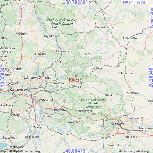
Klucze GPS coordinates[2]
50° 20' 8.34" North, 19° 33' 44.496" East
| Map corner | latitude | longitude |
|---|---|---|
| Upper-left | 50.78233°, | 18.85924° |
| Center: | 50.33565°, | 19.56236° |
| Lower-right: | 49.88473°, | 20.26549° |
| Map W x H: | 99.8×99.8 km | = 62×62mi |
| max Lat: | 54.83135° ⇑71.2% North |
| Klucze: | 50.33565° |
| min Lat: | ⇓28.8% South 49.21328° |
| min Long | Klucze | max Long |
| 14.20249° | 19.56236° | 24.03723° |
| W 50%⇐ | ⇒50% E |
Elevation
Elevation of Klucze is 352 m = 1155 ft, and this is 160.6 m = 527 ft above average elevation for this country.
| Max E: |
974 m = 3196 ft | 8.2% |
| Klucze | 352 m 1155 ft | |
| Avg. | 191.4 m = 628 ft | |
Min E: |
-3 m = -10 ft | 91.8% |
See also: Poland elevation on elevation.city.
Geographical zone
Klucze is located in North temperate zone (between Tropic of Cancer and the Arctic Circle). Distance of this North polar circle is 1804.4 km =1121.2 mi to North.| Distance of | km | miles | from Klucze |
|---|---|---|---|
| North Pole | 4410.3 | 2740.4 | to North |
| Arctic Circle | 1804.4 | 1121.2 | to North |
| Tropic Cancer | 2990.9 | 1858.5 | to South |
| Equator | 5596.8 | 3477.7 | to South |


Nearby cities:
15 places around Klucze: (largest is in red/bold)
• Bolesław
7.2 km =4.5 mi,  233°
233°
• Bukowno
10.7 km =6.6 mi,  222°
222°
• Krzykawka
10.4 km =6.5 mi,  255°
255°
• Lgota
14.3 km =8.9 mi,  182°
182°
• Niegowonice
11.6 km =7.2 mi,  300°
300°
• Niesułowice
12.6 km =7.8 mi, 181°
• Ogrodzieniec
13.3 km =8.3 mi,  346°
346°
• Olkusz
6 km =3.7 mi, 178°
• Osiek
10.6 km =6.6 mi,  165°
165°
• Przeginia
14.1 km =8.8 mi,  140°
140°
• Rokitno Szlacheckie
14.1 km =8.8 mi,  319°
319°
• Sieniczno
8.4 km =5.2 mi,  154°
154°
• Sułoszowa
14.3 km =8.9 mi,  121°
121°
• Sławków
12.9 km =8 mi,  251°
251°
• Zarzecze
10.1 km =6.3 mi,  69°
69°
Sources, notices
• [Note1] Compared only with cities in Poland existing in our database
• [Src1] Map data: © OpenStreetMap contributors (CC-BY-SA)
• [Src2] Other city data from geonames.org with taken over terms of usage.
• [Src3] Geographical zone / Annual Mean Temperature by Robert A. Rohde @ Wikipedia
