Bukowno geodata
Bukowno (Lesser Poland) is a populated place; located in Poland in Europe/Warsaw (GMT+2) time zone. With population of 10,874 people, there are 420 cities with bigger population in this country. Compared to other cities in Poland, 72.8% of cities are located further ↑North; 51.7% of cities are located further →East and 88.6% of cities have lower elevation than Bukowno. Note1


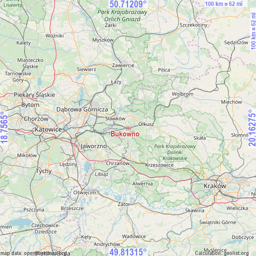
Bukowno GPS coordinates[2]
50° 15' 53.064" North, 19° 27' 34.632" East
| Map corner | latitude | longitude |
|---|---|---|
| Upper-left | 50.71209°, | 18.7565° |
| Center: | 50.26474°, | 19.45962° |
| Lower-right: | 49.81315°, | 20.16275° |
| Map W x H: | 100×100 km | = 62.1×62.1mi |
| max Lat: | 54.83135° ⇑72.8% North |
| Bukowno: | 50.26474° |
| min Lat: | ⇓27.2% South 49.21328° |
| min Long | Bukowno | max Long |
| 14.20249° | 19.45962° | 24.03723° |
| W 48.3%⇐ | ⇒51.7% E |
Elevation
Elevation of Bukowno is 314 m = 1030 ft, and this is 122.6 m = 402 ft above average elevation for this country.
| Max E: |
974 m = 3196 ft | 11.4% |
| Bukowno | 314 m 1030 ft | |
| Avg. | 191.4 m = 628 ft | |
Min E: |
-3 m = -10 ft | 88.6% |
See also: Poland elevation on elevation.city.
Geographical zone
Bukowno is located in North temperate zone (between Tropic of Cancer and the Arctic Circle). Distance of this North polar circle is 1812.3 km =1126.1 mi to North.| Distance of | km | miles | from Bukowno |
|---|---|---|---|
| North Pole | 4418.1 | 2745.3 | to North |
| Arctic Circle | 1812.3 | 1126.1 | to North |
| Tropic Cancer | 2983 | 1853.5 | to South |
| Equator | 5588.9 | 3472.8 | to South |


Nearby cities:
15 places around Bukowno: (largest is in red/bold)
• Bolesław
3.9 km =2.4 mi,  22°
22°
• Klucze
10.7 km =6.6 mi,  42°
42°
• Krzykawka
6 km =3.7 mi,  331°
331°
• Lgota
9.4 km =5.8 mi,  133°
133°
• Luszowice
10.8 km =6.7 mi,  201°
201°
• Myślachowice
9 km =5.6 mi,  170°
170°
• Niesułowice
8.4 km =5.2 mi,  124°
124°
• Olkusz
7.7 km =4.8 mi,  76°
76°
• Osiek
10.3 km =6.4 mi,  103°
103°
• Ostrężnica
11.3 km =7 mi,  135°
135°
• Psary
11.4 km =7.1 mi,  154°
154°
• Płoki
7.7 km =4.8 mi, 149°
• Sieniczno
10.9 km =6.8 mi,  88°
88°
• Sławków
6.3 km =3.9 mi,  307°
307°
• Trzebinia
11.7 km =7.3 mi,  176°
176°
Sources, notices
• [Note1] Compared only with cities in Poland existing in our database
• [Src1] Map data: © OpenStreetMap contributors (CC-BY-SA)
• [Src2] Other city data from geonames.org with taken over terms of usage.
• [Src3] Geographical zone / Annual Mean Temperature by Robert A. Rohde @ Wikipedia
