Niegowonice geodata
Niegowonice (Silesia) is a populated place; located in Poland in Europe/Warsaw (GMT+2) time zone. With population of 2,453 people, there are 1268 cities with bigger population in this country. Compared to other cities in Poland, 69.7% of cities are located further ↑North; 52.3% of cities are located further →East and 91.2% of cities have lower elevation than Niegowonice. Note1


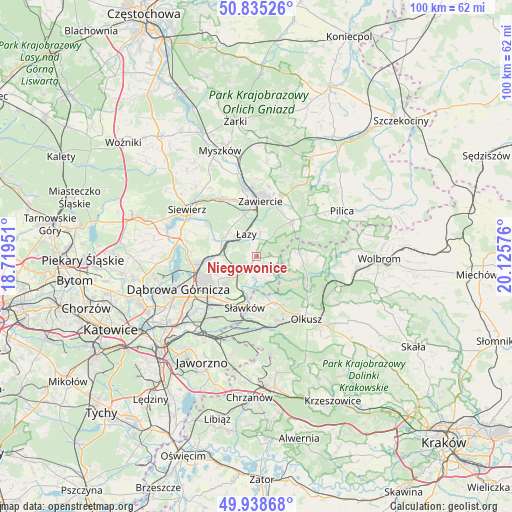
Niegowonice GPS coordinates[2]
50° 23' 20.724" North, 19° 25' 21.468" East
| Map corner | latitude | longitude |
|---|---|---|
| Upper-left | 50.83526°, | 18.71951° |
| Center: | 50.38909°, | 19.42263° |
| Lower-right: | 49.93868°, | 20.12576° |
| Map W x H: | 99.7×99.7 km | = 62×62mi |
| max Lat: | 54.83135° ⇑69.7% North |
| Niegowonice: | 50.38909° |
| min Lat: | ⇓30.3% South 49.21328° |
| min Long | Niegowonice | max Long |
| 14.20249° | 19.42263° | 24.03723° |
| W 47.7%⇐ | ⇒52.3% E |
Elevation
Elevation of Niegowonice is 347 m = 1138 ft, and this is 155.6 m = 510 ft above average elevation for this country.
| Max E: |
974 m = 3196 ft | 8.8% |
| Niegowonice | 347 m 1138 ft | |
| Avg. | 191.4 m = 628 ft | |
Min E: |
-3 m = -10 ft | 91.2% |
See also: Poland elevation on elevation.city.
Geographical zone
Niegowonice is located in North temperate zone (between Tropic of Cancer and the Arctic Circle). Distance of this North polar circle is 1798.4 km =1117.5 mi to North.| Distance of | km | miles | from Niegowonice |
|---|---|---|---|
| North Pole | 4404.3 | 2736.7 | to North |
| Arctic Circle | 1798.4 | 1117.5 | to North |
| Tropic Cancer | 2996.8 | 1862.1 | to South |
| Equator | 5602.7 | 3481.4 | to South |


Nearby cities:
15 places around Niegowonice: (largest is in red/bold)
• Bolesław
11 km =6.8 mi,  158°
158°
• Bukowno
14.1 km =8.8 mi,  169°
169°
• Chruszczobród
7.3 km =4.5 mi,  292°
292°
• Ciągowice
7.7 km =4.8 mi,  327°
327°
• Klucze
11.6 km =7.2 mi,  120°
120°
• Krzykawka
8.5 km =5.3 mi,  181°
181°
• Ogrodzieniec
9.8 km =6.1 mi,  44°
44°
• Olkusz
15.7 km =9.8 mi,  139°
139°
• Poręba
12.5 km =7.8 mi, 331°
• Rokitno Szlacheckie
4.8 km =3 mi,  8°
8°
• Rudniki
14.7 km =9.1 mi,  2°
2°
• Sławków
10.2 km =6.3 mi,  193°
193°
• Wysoka
6.7 km =4.2 mi,  312°
312°
• Zawiercie
11 km =6.8 mi,  357°
357°
• Łazy
4.7 km =2.9 mi,  335°
335°
Sources, notices
• [Note1] Compared only with cities in Poland existing in our database
• [Src1] Map data: © OpenStreetMap contributors (CC-BY-SA)
• [Src2] Other city data from geonames.org with taken over terms of usage.
• [Src3] Geographical zone / Annual Mean Temperature by Robert A. Rohde @ Wikipedia
