Siedlec geodata
Siedlec (Greater Poland) is a populated place; located in Poland in Europe/Warsaw (GMT+2) time zone. With population of 580 people, there are 3338 cities with bigger population in this country. Compared to other cities in Poland, 62% of cities are located further ↓South; 83% of cities are located further →East and 68.6% of cities have higher elevation than Siedlec. Note1


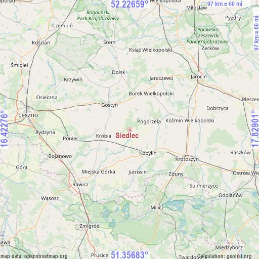
Siedlec GPS coordinates[2]
51° 47' 37.716" North, 17° 7' 33.168" East
| Map corner | latitude | longitude |
|---|---|---|
| Upper-left | 52.22659°, | 16.42276° |
| Center: | 51.79381°, | 17.12588° |
| Lower-right: | 51.35683°, | 17.82901° |
| Map W x H: | 96.7×96.7 km | = 60.1×60.1mi |
| max Lat: | 54.83135° ⇑38% North |
| Siedlec: | 51.79381° |
| min Lat: | ⇓62% South 49.21328° |
| min Long | Siedlec | max Long |
| 14.20249° | 17.12588° | 24.03723° |
| W 17%⇐ | ⇒83% E |
Elevation
Elevation of Siedlec is 124 m = 407 ft, and this is 67.4 m = 221 ft below average elevation for this country.
| Max E: |
974 m = 3196 ft | 68.6% |
| Avg. | 191.4 m = 628 ft | |
| Siedlec | 124 m = 407 ft | |
Min E: |
-3 m = -10 ft | 31.4% |
See also: Poland elevation on elevation.city.
Geographical zone
Siedlec is located in North temperate zone (between Tropic of Cancer and the Arctic Circle). Distance of this North polar circle is 1642.2 km =1020.4 mi to North.| Distance of | km | miles | from Siedlec |
|---|---|---|---|
| North Pole | 4248.1 | 2639.6 | to North |
| Arctic Circle | 1642.2 | 1020.4 | to North |
| Tropic Cancer | 3153 | 1959.2 | to South |
| Equator | 5758.9 | 3578.4 | to South |


Nearby cities:
15 places around Siedlec: (largest is in red/bold)
• Borek Wielkopolski
15.8 km =9.8 mi,  30°
30°
• Chojno
20.4 km =12.7 mi,  203°
203°
• Dolsk
21.3 km =13.2 mi,  348°
348°
• Gostyń
12.6 km =7.8 mi,  321°
321°
• Jutrosin
16.3 km =10.1 mi,  169°
169°
• Kobylin
11.1 km =6.9 mi,  141°
141°
• Konary
16.3 km =10.1 mi, 200°
• Krobia
10.1 km =6.3 mi,  257°
257°
• Krzemieniewo
21.4 km =13.3 mi,  289°
289°
• Miejska Górka
19.2 km =11.9 mi,  216°
216°
• Pakosław
20.5 km =12.7 mi,  193°
193°
• Piaski
10.8 km =6.7 mi,  340°
340°
• Pogorzela
7.8 km =4.8 mi,  66°
66°
• Pępowo
3.1 km =1.9 mi,  179°
179°
• Sułkowice
5.9 km =3.7 mi,  265°
265°
Sources, notices
• [Note1] Compared only with cities in Poland existing in our database
• [Src1] Map data: © OpenStreetMap contributors (CC-BY-SA)
• [Src2] Other city data from geonames.org with taken over terms of usage.
• [Src3] Geographical zone / Annual Mean Temperature by Robert A. Rohde @ Wikipedia
