Krzemieniewo geodata
Krzemieniewo (Greater Poland) is a seat of a third-order administrative division; located in Poland in Europe/Warsaw (GMT+2) time zone. With population of 5,000 people, there are 689 cities with bigger population in this country. Compared to other cities in Poland, 62.9% of cities are located further ↓South; 87% of cities are located further →East and 75.4% of cities have higher elevation than Krzemieniewo. Note1
Administrative division(s):
- Level 1: Greater Poland
- Level 2: Powiat leszczyński
- Level 3: Krzemieniewo


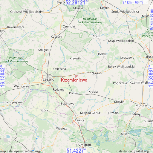
Krzemieniewo GPS coordinates[2]
51° 51' 32.58" North, 16° 50' 0.744" East
| Map corner | latitude | longitude |
|---|---|---|
| Upper-left | 52.29121°, | 16.13042° |
| Center: | 51.85905°, | 16.83354° |
| Lower-right: | 51.4227°, | 17.53667° |
| Map W x H: | 96.6×96.6 km | = 60×60mi |
| max Lat: | 54.83135° ⇑37.1% North |
| Krzemieniewo: | 51.85905° |
| min Lat: | ⇓62.9% South 49.21328° |
| min Long | Krzemieniewo | max Long |
| 14.20249° | 16.83354° | 24.03723° |
| W 13%⇐ | ⇒87% E |
Elevation
Elevation of Krzemieniewo is 110 m = 361 ft, and this is 81.4 m = 267 ft below average elevation for this country.
| Max E: |
974 m = 3196 ft | 75.4% |
| Avg. | 191.4 m = 628 ft | |
| Krzemieniewo | 110 m = 361 ft | |
Min E: |
-3 m = -10 ft | 24.6% |
See also: Poland elevation on elevation.city.
Geographical zone
Krzemieniewo is located in North temperate zone (between Tropic of Cancer and the Arctic Circle). Distance of this North polar circle is 1635 km =1015.9 mi to North.| Distance of | km | miles | from Krzemieniewo |
|---|---|---|---|
| North Pole | 4240.9 | 2635.2 | to North |
| Arctic Circle | 1635 | 1015.9 | to North |
| Tropic Cancer | 3160.3 | 1963.7 | to South |
| Equator | 5766.2 | 3582.9 | to South |


Nearby cities:
15 places around Krzemieniewo: (largest is in red/bold)
• Bojanowo
17.8 km =11.1 mi,  199°
199°
• Dolsk
20.8 km =12.9 mi,  49°
49°
• Golina Wielka
18 km =11.2 mi,  190°
190°
• Gostyń
12.5 km =7.8 mi,  78°
78°
• Krobia
13.9 km =8.6 mi,  132°
132°
• Krzywiń
11.6 km =7.2 mi,  355°
355°
• Leszno
17.9 km =11.1 mi,  263°
263°
• Lipno
19.4 km =12.1 mi,  289°
289°
• Lubiń
12.6 km =7.8 mi,  20°
20°
• Osieczna
11.8 km =7.3 mi,  295°
295°
• Piaski
16.7 km =10.4 mi, 80°
• Poniec
10.8 km =6.7 mi, 189°
• Rydzyna
14 km =8.7 mi,  234°
234°
• Sułkowice
16.2 km =10.1 mi,  118°
118°
• Wilkowice
20.8 km =12.9 mi,  278°
278°
Sources, notices
• [Note1] Compared only with cities in Poland existing in our database
• [Src1] Map data: © OpenStreetMap contributors (CC-BY-SA)
• [Src2] Other city data from geonames.org with taken over terms of usage.
• [Src3] Geographical zone / Annual Mean Temperature by Robert A. Rohde @ Wikipedia
