Piaski geodata
Piaski (Greater Poland) is a seat of a third-order administrative division; located in Poland in Europe/Warsaw (GMT+2) time zone. With population of 3,157 people, there are 1003 cities with bigger population in this country. Compared to other cities in Poland, 63.3% of cities are located further ↓South; 83.6% of cities are located further →East and 80.6% of cities have higher elevation than Piaski. Note1


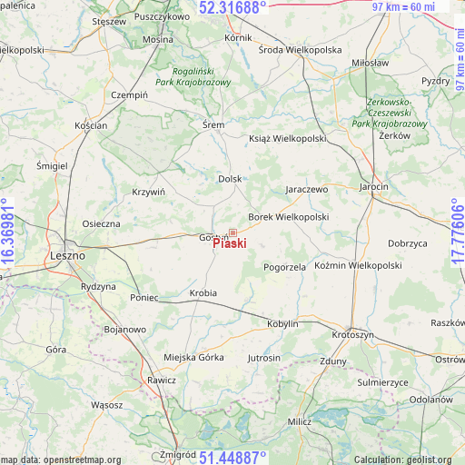
Piaski GPS coordinates[2]
51° 53' 5.892" North, 17° 4' 22.548" East
| Map corner | latitude | longitude |
|---|---|---|
| Upper-left | 52.31688°, | 16.36981° |
| Center: | 51.88497°, | 17.07293° |
| Lower-right: | 51.44887°, | 17.77606° |
| Map W x H: | 96.5×96.5 km | = 60×60mi |
| max Lat: | 54.83135° ⇑36.7% North |
| Piaski: | 51.88497° |
| min Lat: | ⇓63.3% South 49.21328° |
| min Long | Piaski | max Long |
| 14.20249° | 17.07293° | 24.03723° |
| W 16.4%⇐ | ⇒83.6% E |
Elevation
Elevation of Piaski is 98 m = 322 ft, and this is 93.4 m = 306 ft below average elevation for this country.
| Max E: |
974 m = 3196 ft | 80.6% |
| Avg. | 191.4 m = 628 ft | |
| Piaski | 98 m = 322 ft | |
Min E: |
-3 m = -10 ft | 19.4% |
See also: Poland elevation on elevation.city.
Geographical zone
Piaski is located in North temperate zone (between Tropic of Cancer and the Arctic Circle). Distance of this North polar circle is 1632.1 km =1014.1 mi to North.| Distance of | km | miles | from Piaski |
|---|---|---|---|
| North Pole | 4238 | 2633.4 | to North |
| Arctic Circle | 1632.1 | 1014.1 | to North |
| Tropic Cancer | 3163.1 | 1965.5 | to South |
| Equator | 5769.1 | 3584.8 | to South |


Nearby cities:
15 places around Piaski: (largest is in red/bold)
• Borek Wielkopolski
12.1 km =7.5 mi,  72°
72°
• Dolsk
10.8 km =6.7 mi,  356°
356°
• Gostyń
4.2 km =2.6 mi,  266°
266°
• Jaraczewo
18 km =11.2 mi,  58°
58°
• Kobylin
21.5 km =13.4 mi,  150°
150°
• Krobia
13.8 km =8.6 mi,  206°
206°
• Krzemieniewo
16.7 km =10.4 mi,  260°
260°
• Krzywiń
19.4 km =12.1 mi,  296°
296°
• Lubiń
14.9 km =9.3 mi,  306°
306°
• Nochowo
21.9 km =13.6 mi,  342°
342°
• Pogorzela
12.9 km =8 mi,  122°
122°
• Poniec
22.6 km =14 mi,  233°
233°
• Pępowo
13.8 km =8.6 mi,  164°
164°
• Siedlec
10.8 km =6.7 mi, 160°
• Sułkowice
10.8 km =6.7 mi,  191°
191°
Sources, notices
• [Note1] Compared only with cities in Poland existing in our database
• [Src1] Map data: © OpenStreetMap contributors (CC-BY-SA)
• [Src2] Other city data from geonames.org with taken over terms of usage.
• [Src3] Geographical zone / Annual Mean Temperature by Robert A. Rohde @ Wikipedia
