Jutrosin geodata
Jutrosin (Greater Poland) is a seat of a third-order administrative division; located in Poland in Europe/Warsaw (GMT+2) time zone. With population of 1,908 people, there are 1545 cities with bigger population in this country. Compared to other cities in Poland, 59.1% of cities are located further ↓South; 82.5% of cities are located further →East and 76.4% of cities have higher elevation than Jutrosin. Note1


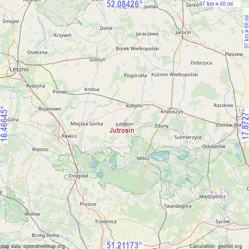
Jutrosin GPS coordinates[2]
51° 39' 0.324" North, 17° 10' 10.452" East
| Map corner | latitude | longitude |
|---|---|---|
| Upper-left | 52.08426°, | 16.46645° |
| Center: | 51.65009°, | 17.16957° |
| Lower-right: | 51.21173°, | 17.8727° |
| Map W x H: | 97×97 km | = 60.3×60.3mi |
| max Lat: | 54.83135° ⇑40.9% North |
| Jutrosin: | 51.65009° |
| min Lat: | ⇓59.1% South 49.21328° |
| min Long | Jutrosin | max Long |
| 14.20249° | 17.16957° | 24.03723° |
| W 17.5%⇐ | ⇒82.5% E |
Elevation
Elevation of Jutrosin is 107 m = 351 ft, and this is 84.4 m = 277 ft below average elevation for this country.
| Max E: |
974 m = 3196 ft | 76.4% |
| Avg. | 191.4 m = 628 ft | |
| Jutrosin | 107 m = 351 ft | |
Min E: |
-3 m = -10 ft | 23.6% |
See also: Poland elevation on elevation.city.
Geographical zone
Jutrosin is located in North temperate zone (between Tropic of Cancer and the Arctic Circle). Distance of this North polar circle is 1658.2 km =1030.4 mi to North.| Distance of | km | miles | from Jutrosin |
|---|---|---|---|
| North Pole | 4264.1 | 2649.6 | to North |
| Arctic Circle | 1658.2 | 1030.4 | to North |
| Tropic Cancer | 3137 | 1949.2 | to South |
| Equator | 5743 | 3568.5 | to South |


Nearby cities:
15 places around Jutrosin: (largest is in red/bold)
• Chojno
11.4 km =7.1 mi,  256°
256°
• Cieszków
13.1 km =8.1 mi,  99°
99°
• Kobylin
8.4 km =5.2 mi,  28°
28°
• Konary
8.8 km =5.5 mi,  274°
274°
• Krobia
18.9 km =11.7 mi,  316°
316°
• Krotoszyn
19.2 km =11.9 mi,  73°
73°
• Miejska Górka
14.6 km =9.1 mi, 272°
• Milicz
15.3 km =9.5 mi,  152°
152°
• Pakosław
8.7 km =5.4 mi,  242°
242°
• Pępowo
13.2 km =8.2 mi,  347°
347°
• Siedlec
16.3 km =10.1 mi, 349°
• Sułkowice
17.9 km =11.1 mi,  330°
330°
• Sułów
16.7 km =10.4 mi,  180°
180°
• Słupia Kapitulna
15.3 km =9.5 mi,  252°
252°
• Zduny
14.3 km =8.9 mi,  91°
91°
Sources, notices
• [Note1] Compared only with cities in Poland existing in our database
• [Src1] Map data: © OpenStreetMap contributors (CC-BY-SA)
• [Src2] Other city data from geonames.org with taken over terms of usage.
• [Src3] Geographical zone / Annual Mean Temperature by Robert A. Rohde @ Wikipedia
