Chojno geodata
Chojno (Greater Poland) is a populated place; located in Poland in Europe/Warsaw (GMT+2) time zone. With population of 867 people, there are 2737 cities with bigger population in this country. Compared to other cities in Poland, 58.5% of cities are located further ↓South; 84.7% of cities are located further →East and 78.4% of cities have higher elevation than Chojno. Note1


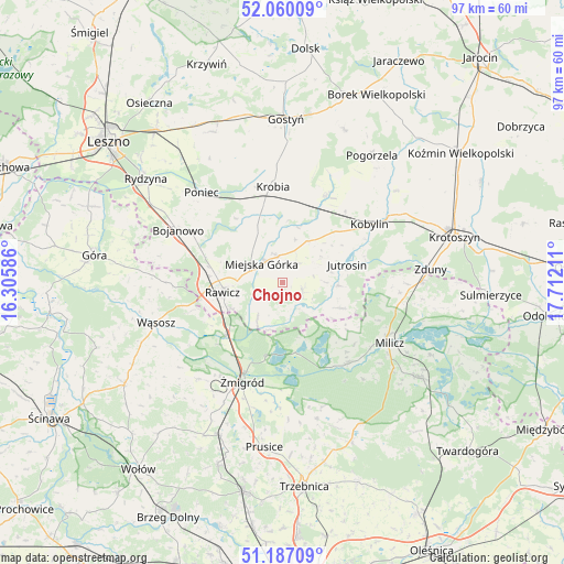
Chojno GPS coordinates[2]
51° 37' 32.484" North, 17° 0' 32.328" East
| Map corner | latitude | longitude |
|---|---|---|
| Upper-left | 52.06009°, | 16.30586° |
| Center: | 51.62569°, | 17.00898° |
| Lower-right: | 51.18709°, | 17.71211° |
| Map W x H: | 97.1×97.1 km | = 60.3×60.3mi |
| max Lat: | 54.83135° ⇑41.5% North |
| Chojno: | 51.62569° |
| min Lat: | ⇓58.5% South 49.21328° |
| min Long | Chojno | max Long |
| 14.20249° | 17.00898° | 24.03723° |
| W 15.3%⇐ | ⇒84.7% E |
Elevation
Elevation of Chojno is 103 m = 338 ft, and this is 88.4 m = 290 ft below average elevation for this country.
| Max E: |
974 m = 3196 ft | 78.4% |
| Avg. | 191.4 m = 628 ft | |
| Chojno | 103 m = 338 ft | |
Min E: |
-3 m = -10 ft | 21.6% |
See also: Poland elevation on elevation.city.
Geographical zone
Chojno is located in North temperate zone (between Tropic of Cancer and the Arctic Circle). Distance of this North polar circle is 1660.9 km =1032 mi to North.| Distance of | km | miles | from Chojno |
|---|---|---|---|
| North Pole | 4266.8 | 2651.3 | to North |
| Arctic Circle | 1660.9 | 1032 | to North |
| Tropic Cancer | 3134.3 | 1947.6 | to South |
| Equator | 5740.2 | 3566.8 | to South |


Nearby cities:
15 places around Chojno: (largest is in red/bold)
• Dębno Polskie
10 km =6.2 mi,  243°
243°
• Golina Wielka
17.6 km =10.9 mi,  298°
298°
• Jutrosin
11.4 km =7.1 mi,  76°
76°
• Kobylin
18.1 km =11.2 mi,  56°
56°
• Konary
4.1 km =2.5 mi,  33°
33°
• Krobia
16.6 km =10.3 mi,  353°
353°
• Miejska Górka
4.8 km =3 mi,  313°
313°
• Pakosław
3.6 km =2.2 mi,  110°
110°
• Pępowo
17.6 km =10.9 mi, 27°
• Rawicz
10.5 km =6.5 mi,  260°
260°
• Sułkowice
18.4 km =11.4 mi,  6°
6°
• Sułów
17.8 km =11.1 mi,  141°
141°
• Szymanowo
8.3 km =5.2 mi,  253°
253°
• Słupia Kapitulna
4 km =2.5 mi, 240°
• Żmigród
19.1 km =11.9 mi,  202°
202°
Sources, notices
• [Note1] Compared only with cities in Poland existing in our database
• [Src1] Map data: © OpenStreetMap contributors (CC-BY-SA)
• [Src2] Other city data from geonames.org with taken over terms of usage.
• [Src3] Geographical zone / Annual Mean Temperature by Robert A. Rohde @ Wikipedia
