Sułkowice geodata
Sułkowice (Greater Poland) is a populated place; located in Poland in Europe/Warsaw (GMT+2) time zone. With population of 620 people, there are 3226 cities with bigger population in this country. Compared to other cities in Poland, 61.9% of cities are located further ↓South; 84.1% of cities are located further →East and 67.8% of cities have higher elevation than Sułkowice. Note1


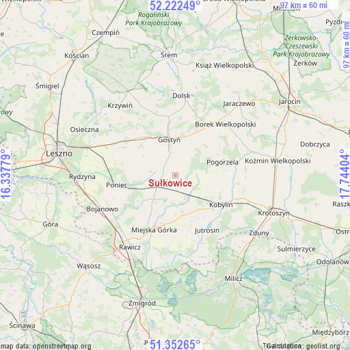
Sułkowice GPS coordinates[2]
51° 47' 22.812" North, 17° 2' 27.276" East
| Map corner | latitude | longitude |
|---|---|---|
| Upper-left | 52.22249°, | 16.33779° |
| Center: | 51.78967°, | 17.04091° |
| Lower-right: | 51.35265°, | 17.74404° |
| Map W x H: | 96.7×96.7 km | = 60.1×60.1mi |
| max Lat: | 54.83135° ⇑38.1% North |
| Sułkowice: | 51.78967° |
| min Lat: | ⇓61.9% South 49.21328° |
| min Long | Sułkowice | max Long |
| 14.20249° | 17.04091° | 24.03723° |
| W 15.9%⇐ | ⇒84.1% E |
Elevation
Elevation of Sułkowice is 126 m = 413 ft, and this is 65.4 m = 215 ft below average elevation for this country.
| Max E: |
974 m = 3196 ft | 67.8% |
| Avg. | 191.4 m = 628 ft | |
| Sułkowice | 126 m = 413 ft | |
Min E: |
-3 m = -10 ft | 32.2% |
See also: Poland elevation on elevation.city.
Geographical zone
Sułkowice is located in North temperate zone (between Tropic of Cancer and the Arctic Circle). Distance of this North polar circle is 1642.7 km =1020.7 mi to North.| Distance of | km | miles | from Sułkowice |
|---|---|---|---|
| North Pole | 4248.6 | 2640 | to North |
| Arctic Circle | 1642.7 | 1020.7 | to North |
| Tropic Cancer | 3152.6 | 1958.9 | to South |
| Equator | 5758.5 | 3578.2 | to South |


Nearby cities:
15 places around Sułkowice: (largest is in red/bold)
• Borek Wielkopolski
19.7 km =12.2 mi,  44°
44°
• Chojno
18.4 km =11.4 mi,  186°
186°
• Gostyń
10.5 km =6.5 mi,  349°
349°
• Jutrosin
17.9 km =11.1 mi,  150°
150°
• Kobylin
15.2 km =9.4 mi,  122°
122°
• Konary
14.8 km =9.2 mi,  179°
179°
• Krobia
4.4 km =2.7 mi,  246°
246°
• Krzemieniewo
16.2 km =10.1 mi,  298°
298°
• Miejska Górka
15.9 km =9.9 mi,  200°
200°
• Pakosław
19.5 km =12.1 mi, 176°
• Piaski
10.8 km =6.7 mi,  11°
11°
• Pogorzela
13.5 km =8.4 mi,  74°
74°
• Poniec
16.2 km =10.1 mi,  259°
259°
• Pępowo
6.5 km =4 mi,  114°
114°
• Siedlec
5.9 km =3.7 mi,  85°
85°
Sources, notices
• [Note1] Compared only with cities in Poland existing in our database
• [Src1] Map data: © OpenStreetMap contributors (CC-BY-SA)
• [Src2] Other city data from geonames.org with taken over terms of usage.
• [Src3] Geographical zone / Annual Mean Temperature by Robert A. Rohde @ Wikipedia
