Pyzówka geodata
Pyzówka (Lesser Poland) is a populated place; located in Poland in Europe/Warsaw (GMT+2) time zone. With population of 901 people, there are 2671 cities with bigger population in this country. Compared to other cities in Poland, 98% of cities are located further ↑North; 57.3% of cities are located further ←West and 99.5% of cities have lower elevation than Pyzówka. Note1


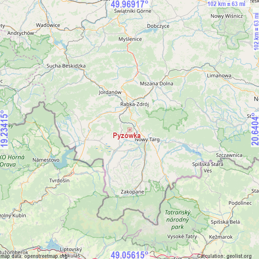
Pyzówka GPS coordinates[2]
49° 30' 53.244" North, 19° 56' 14.172" East
| Map corner | latitude | longitude |
|---|---|---|
| Upper-left | 49.96917°, | 19.23415° |
| Center: | 49.51479°, | 19.93727° |
| Lower-right: | 49.05615°, | 20.6404° |
| Map W x H: | 101.5×101.5 km | = 63.1×63.1mi |
| max Lat: | 54.83135° ⇑98% North |
| Pyzówka: | 49.51479° |
| min Lat: | ⇓2% South 49.21328° |
| min Long | Pyzówka | max Long |
| 14.20249° | 19.93727° | 24.03723° |
| W 57.3%⇐ | ⇒42.7% E |
Elevation
Elevation of Pyzówka is 673 m = 2208 ft, and this is 481.6 m = 1580 ft above average elevation for this country.
| Max E: |
974 m = 3196 ft | 0.5% |
| Pyzówka | 673 m 2208 ft | |
| Avg. | 191.4 m = 628 ft | |
Min E: |
-3 m = -10 ft | 99.5% |
See also: Poland elevation on elevation.city.
Geographical zone
Pyzówka is located in North temperate zone (between Tropic of Cancer and the Arctic Circle). Distance of this North polar circle is 1895.6 km =1177.9 mi to North.| Distance of | km | miles | from Pyzówka |
|---|---|---|---|
| North Pole | 4501.5 | 2797.1 | to North |
| Arctic Circle | 1895.6 | 1177.9 | to North |
| Tropic Cancer | 2899.6 | 1801.7 | to South |
| Equator | 5505.5 | 3421 | to South |


Nearby cities:
15 places around Pyzówka: (largest is in red/bold)
• Harkabuz
7.8 km =4.8 mi,  289°
289°
• Klikuszowa
3.5 km =2.2 mi,  81°
81°
• Krauszów
4.7 km =2.9 mi,  162°
162°
• Lasek
3.2 km =2 mi,  101°
101°
• Ludźmierz
6.3 km =3.9 mi,  148°
148°
• Nowy Targ
8 km =5 mi,  120°
120°
• Odrowąż
6.4 km =4 mi,  251°
251°
• Pieniążkowice
4.5 km =2.8 mi, 245°
• Raba Wyżna
7.1 km =4.4 mi,  324°
324°
• Rokiciny
6.5 km =4 mi,  350°
350°
• Sieniawa
2.8 km =1.7 mi, 349°
• Spytkowice
10.2 km =6.3 mi,  312°
312°
• Trute
3.4 km =2.1 mi,  138°
138°
• Wróblówka
7.6 km =4.7 mi,  207°
207°
• Załuczne
9 km =5.6 mi, 253°
Sources, notices
• [Note1] Compared only with cities in Poland existing in our database
• [Src1] Map data: © OpenStreetMap contributors (CC-BY-SA)
• [Src2] Other city data from geonames.org with taken over terms of usage.
• [Src3] Geographical zone / Annual Mean Temperature by Robert A. Rohde @ Wikipedia
