Nowy Targ geodata
Nowy Targ (Lesser Poland) is a seat of a second-order administrative division; located in Poland in Europe/Warsaw (GMT+2) time zone. With population of 33,763 people, there are 153 cities with bigger population in this country. Compared to other cities in Poland, 98.6% of cities are located further ↑North; 58.9% of cities are located further ←West and 98.7% of cities have lower elevation than Nowy Targ. Note1


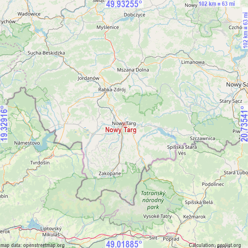
Nowy Targ GPS coordinates[2]
49° 28' 40.188" North, 20° 1' 56.208" East
| Map corner | latitude | longitude |
|---|---|---|
| Upper-left | 49.93255°, | 19.32916° |
| Center: | 49.47783°, | 20.03228° |
| Lower-right: | 49.01885°, | 20.73541° |
| Map W x H: | 101.6×101.6 km | = 63.1×63.1mi |
| max Lat: | 54.83135° ⇑98.6% North |
| Nowy Targ: | 49.47783° |
| min Lat: | ⇓1.4% South 49.21328° |
| min Long | Nowy Targ | max Long |
| 14.20249° | 20.03228° | 24.03723° |
| W 58.9%⇐ | ⇒41.1% E |
Elevation
Elevation of Nowy Targ is 595 m = 1952 ft, and this is 403.6 m = 1324 ft above average elevation for this country.
| Max E: |
974 m = 3196 ft | 1.3% |
| Nowy Targ | 595 m 1952 ft | |
| Avg. | 191.4 m = 628 ft | |
Min E: |
-3 m = -10 ft | 98.7% |
See also: Poland elevation on elevation.city.
Geographical zone
Nowy Targ is located in North temperate zone (between Tropic of Cancer and the Arctic Circle). Distance of this North polar circle is 1899.8 km =1180.5 mi to North.| Distance of | km | miles | from Nowy Targ |
|---|---|---|---|
| North Pole | 4505.6 | 2799.6 | to North |
| Arctic Circle | 1899.8 | 1180.5 | to North |
| Tropic Cancer | 2895.5 | 1799.2 | to South |
| Equator | 5501.4 | 3418.4 | to South |


Nearby cities:
15 places around Nowy Targ: (largest is in red/bold)
• Białka Tatrzańska
11.1 km =6.9 mi,  151°
151°
• Klikuszowa
5.7 km =3.5 mi,  323°
323°
• Krauszów
5.5 km =3.4 mi,  266°
266°
• Lasek
5.1 km =3.2 mi,  312°
312°
• Leśnica
8.8 km =5.5 mi,  166°
166°
• Ludźmierz
3.8 km =2.4 mi,  250°
250°
• Ostrowsko
4.9 km =3 mi,  92°
92°
• Pieniążkowice
11.2 km =7 mi,  281°
281°
• Pyzówka
8 km =5 mi,  300°
300°
• Sieniawa
10.1 km =6.3 mi, 312°
• Szaflary
5.7 km =3.5 mi,  183°
183°
• Trute
4.9 km =3 mi,  288°
288°
• Waksmund
3.2 km =2 mi,  81°
81°
• Wróblówka
10.7 km =6.6 mi,  255°
255°
• Łopuszna
7.1 km =4.4 mi, 94°
Sources, notices
• [Note1] Compared only with cities in Poland existing in our database
• [Src1] Map data: © OpenStreetMap contributors (CC-BY-SA)
• [Src2] Other city data from geonames.org with taken over terms of usage.
• [Src3] Geographical zone / Annual Mean Temperature by Robert A. Rohde @ Wikipedia
