Odrowąż geodata
Odrowąż (Lesser Poland) is a populated place; located in Poland in Europe/Warsaw (GMT+2) time zone. With population of 937 people, there are 2613 cities with bigger population in this country. Compared to other cities in Poland, 98.3% of cities are located further ↑North; 56% of cities are located further ←West and 99.6% of cities have lower elevation than Odrowąż. Note1
Administrative division(s):
- Level 1: Lesser Poland
- Level 2: Powiat nowotarski
- Level 3: Czarny Dunajec


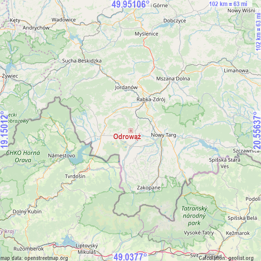
Odrowąż GPS coordinates[2]
49° 29' 47.436" North, 19° 51' 11.664" East
| Map corner | latitude | longitude |
|---|---|---|
| Upper-left | 49.95106°, | 19.15012° |
| Center: | 49.49651°, | 19.85324° |
| Lower-right: | 49.0377°, | 20.55637° |
| Map W x H: | 101.6×101.6 km | = 63.1×63.1mi |
| max Lat: | 54.83135° ⇑98.3% North |
| Odrowąż: | 49.49651° |
| min Lat: | ⇓1.7% South 49.21328° |
| min Long | Odrowąż | max Long |
| 14.20249° | 19.85324° | 24.03723° |
| W 56%⇐ | ⇒44% E |
Elevation
Elevation of Odrowąż is 681 m = 2234 ft, and this is 489.6 m = 1606 ft above average elevation for this country.
| Max E: |
974 m = 3196 ft | 0.40000000000001% |
| Odrowąż | 681 m 2234 ft | |
| Avg. | 191.4 m = 628 ft | |
Min E: |
-3 m = -10 ft | 99.6% |
See also: Poland elevation on elevation.city.
Geographical zone
Odrowąż is located in North temperate zone (between Tropic of Cancer and the Arctic Circle). Distance of this North polar circle is 1897.7 km =1179.2 mi to North.| Distance of | km | miles | from Odrowąż |
|---|---|---|---|
| North Pole | 4503.6 | 2798.4 | to North |
| Arctic Circle | 1897.7 | 1179.2 | to North |
| Tropic Cancer | 2897.6 | 1800.5 | to South |
| Equator | 5503.5 | 3419.7 | to South |


Nearby cities:
15 places around Odrowąż: (largest is in red/bold)
• Czarny Dunajec
6.7 km =4.2 mi,  181°
181°
• Harkabuz
4.8 km =3 mi,  344°
344°
• Krauszów
7.8 km =4.8 mi,  107°
107°
• Lasek
9.3 km =5.8 mi,  81°
81°
• Orawka
9.5 km =5.9 mi,  282°
282°
• Piekielnik
6.5 km =4 mi,  250°
250°
• Pieniążkowice
2 km =1.2 mi,  85°
85°
• Podsarnie
7.7 km =4.8 mi,  323°
323°
• Pyzówka
6.4 km =4 mi,  71°
71°
• Raba Wyżna
8 km =5 mi,  13°
13°
• Sieniawa
7.3 km =4.5 mi,  49°
49°
• Spytkowice
9.1 km =5.7 mi,  350°
350°
• Trute
8.3 km =5.2 mi, 93°
• Wróblówka
5.4 km =3.4 mi,  151°
151°
• Załuczne
2.6 km =1.6 mi,  259°
259°
Sources, notices
• [Note1] Compared only with cities in Poland existing in our database
• [Src1] Map data: © OpenStreetMap contributors (CC-BY-SA)
• [Src2] Other city data from geonames.org with taken over terms of usage.
• [Src3] Geographical zone / Annual Mean Temperature by Robert A. Rohde @ Wikipedia
