Frydek geodata
Frydek (Silesia) is a populated place; located in Poland in Europe/Warsaw (GMT+2) time zone. With population of 1,019 people, there are 2432 cities with bigger population in this country. Compared to other cities in Poland, 82.5% of cities are located further ↑North; 58.8% of cities are located further →East and 75.5% of cities have lower elevation than Frydek. Note1


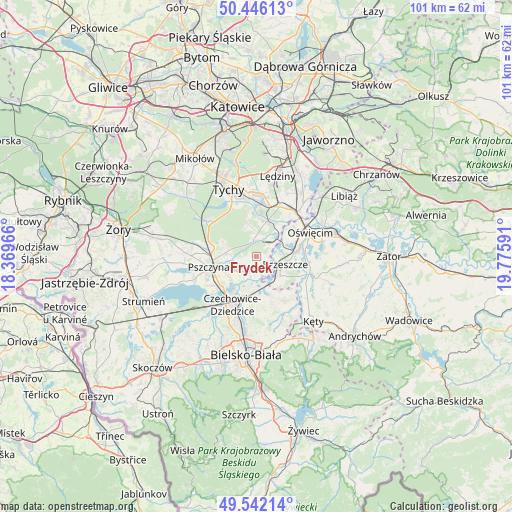
Frydek GPS coordinates[2]
49° 59' 46.536" North, 19° 4' 22.008" East
| Map corner | latitude | longitude |
|---|---|---|
| Upper-left | 50.44613°, | 18.36966° |
| Center: | 49.99626°, | 19.07278° |
| Lower-right: | 49.54214°, | 19.77591° |
| Map W x H: | 100.5×100.5 km | = 62.4×62.4mi |
| max Lat: | 54.83135° ⇑82.5% North |
| Frydek: | 49.99626° |
| min Lat: | ⇓17.5% South 49.21328° |
| min Long | Frydek | max Long |
| 14.20249° | 19.07278° | 24.03723° |
| W 41.2%⇐ | ⇒58.8% E |
Elevation
Elevation of Frydek is 248 m = 814 ft, and this is 56.6 m = 186 ft above average elevation for this country.
| Max E: |
974 m = 3196 ft | 24.5% |
| Frydek | 248 m 814 ft | |
| Avg. | 191.4 m = 628 ft | |
Min E: |
-3 m = -10 ft | 75.5% |
See also: Poland elevation on elevation.city.
Geographical zone
Frydek is located in North temperate zone (between Tropic of Cancer and the Arctic Circle). Distance of this North polar circle is 1842.1 km =1144.6 mi to North.| Distance of | km | miles | from Frydek |
|---|---|---|---|
| North Pole | 4448 | 2763.9 | to North |
| Arctic Circle | 1842.1 | 1144.6 | to North |
| Tropic Cancer | 2953.1 | 1835 | to South |
| Equator | 5559.1 | 3454.3 | to South |


Nearby cities:
15 places around Frydek: (largest is in red/bold)
• Bestwinka
7.1 km =4.4 mi,  183°
183°
• Bojszowy
7.1 km =4.4 mi,  16°
16°
• Bojszowy Nowe
6.5 km =4 mi,  345°
345°
• Brzeszcze
5.9 km =3.7 mi,  105°
105°
• Gilowice
1.7 km =1.1 mi,  94°
94°
• Góra
2.9 km =1.8 mi,  128°
128°
• Harmęże
7 km =4.3 mi,  66°
66°
• Jankowice
6 km =3.7 mi,  274°
274°
• Kaniów
6.1 km =3.8 mi,  194°
194°
• Miedźna
2.3 km =1.4 mi,  227°
227°
• Międzyrzecze
3.2 km =2 mi, 350°
• Przecieszyn
7.3 km =4.5 mi, 105°
• Pszczyna
8.7 km =5.4 mi,  258°
258°
• Rajsko
8.8 km =5.5 mi,  78°
78°
• Wola
4.3 km =2.7 mi,  56°
56°
Sources, notices
• [Note1] Compared only with cities in Poland existing in our database
• [Src1] Map data: © OpenStreetMap contributors (CC-BY-SA)
• [Src2] Other city data from geonames.org with taken over terms of usage.
• [Src3] Geographical zone / Annual Mean Temperature by Robert A. Rohde @ Wikipedia
