Przeginia Narodowa geodata
Przeginia Narodowa (Lesser Poland) is a populated place; located in Poland in Europe/Warsaw (GMT+2) time zone. With population of 545 people, there are 3420 cities with bigger population in this country. Compared to other cities in Poland, 82% of cities are located further ↑North; 52% of cities are located further ←West and 68.1% of cities have lower elevation than Przeginia Narodowa. Note1


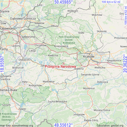
Przeginia Narodowa GPS coordinates[2]
50° 0' 36.396" North, 19° 39' 32.724" East
| Map corner | latitude | longitude |
|---|---|---|
| Upper-left | 50.45985°, | 18.95597° |
| Center: | 50.01011°, | 19.65909° |
| Lower-right: | 49.55612°, | 20.36222° |
| Map W x H: | 100.5×100.5 km | = 62.4×62.4mi |
| max Lat: | 54.83135° ⇑82% North |
| Przeginia Narodowa: | 50.01011° |
| min Lat: | ⇓18% South 49.21328° |
| min Long | Przeginia Narod | max Long |
| 14.20249° | 19.65909° | 24.03723° |
| W 52%⇐ | ⇒48% E |
Elevation
Elevation of Przeginia Narodowa is 223 m = 732 ft, and this is 31.6 m = 104 ft above average elevation for this country.
| Max E: |
974 m = 3196 ft | 31.9% |
| Przeginia Narodowa | 223 m 732 ft | |
| Avg. | 191.4 m = 628 ft | |
Min E: |
-3 m = -10 ft | 68.1% |
See also: Poland elevation on elevation.city.
Geographical zone
Przeginia Narodowa is located in North temperate zone (between Tropic of Cancer and the Arctic Circle). Distance of this North polar circle is 1840.6 km =1143.7 mi to North.| Distance of | km | miles | from Przeginia Narodowa |
|---|---|---|---|
| North Pole | 4446.5 | 2762.9 | to North |
| Arctic Circle | 1840.6 | 1143.7 | to North |
| Tropic Cancer | 2954.7 | 1836 | to South |
| Equator | 5560.6 | 3455.2 | to South |


Nearby cities:
15 places around Przeginia Narodowa: (largest is in red/bold)
• Brodła
6.2 km =3.9 mi,  306°
306°
• Brzeźnica
5.8 km =3.6 mi,  209°
209°
• Czernichów
2.8 km =1.7 mi,  145°
145°
• Czułów
6.3 km =3.9 mi,  28°
28°
• Facimiech
6.5 km =4 mi,  137°
137°
• Kamień
5.3 km =3.3 mi,  272°
272°
• Kaszów
5.4 km =3.4 mi,  53°
53°
• Mników
7.4 km =4.6 mi,  40°
40°
• Nowa Wieś Szlachecka
3.3 km =2.1 mi,  55°
55°
• Pozowice
4.9 km =3 mi, 145°
• Przeginia Duchowna
1.3 km =0.8 mi,  341°
341°
• Rusocice
4.1 km =2.5 mi,  247°
247°
• Sanka
6.6 km =4.1 mi,  351°
351°
• Wołowice
5.4 km =3.4 mi,  116°
116°
• Łączany
6.4 km =4 mi,  243°
243°
Sources, notices
• [Note1] Compared only with cities in Poland existing in our database
• [Src1] Map data: © OpenStreetMap contributors (CC-BY-SA)
• [Src2] Other city data from geonames.org with taken over terms of usage.
• [Src3] Geographical zone / Annual Mean Temperature by Robert A. Rohde @ Wikipedia
