Czernichów geodata
Czernichów (Lesser Poland) is a seat of a third-order administrative division; located in Poland in Europe/Warsaw (GMT+2) time zone. With population of 1,707 people, there are 1671 cities with bigger population in this country. Compared to other cities in Poland, 83.1% of cities are located further ↑North; 52.4% of cities are located further ←West and 70.9% of cities have lower elevation than Czernichów. Note1


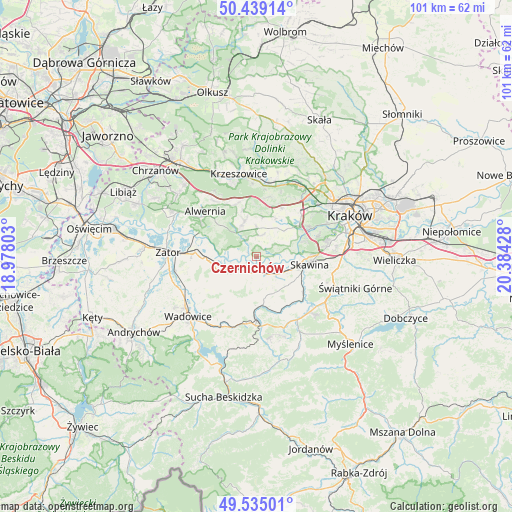
Czernichów GPS coordinates[2]
49° 59' 21.12" North, 19° 40' 52.14" East
| Map corner | latitude | longitude |
|---|---|---|
| Upper-left | 50.43914°, | 18.97803° |
| Center: | 49.9892°, | 19.68115° |
| Lower-right: | 49.53501°, | 20.38428° |
| Map W x H: | 100.5×100.5 km | = 62.4×62.4mi |
| max Lat: | 54.83135° ⇑83.1% North |
| Czernichów: | 49.9892° |
| min Lat: | ⇓16.9% South 49.21328° |
| min Long | Czernichów | max Long |
| 14.20249° | 19.68115° | 24.03723° |
| W 52.4%⇐ | ⇒47.6% E |
Elevation
Elevation of Czernichów is 232 m = 761 ft, and this is 40.6 m = 133 ft above average elevation for this country.
| Max E: |
974 m = 3196 ft | 29.1% |
| Czernichów | 232 m 761 ft | |
| Avg. | 191.4 m = 628 ft | |
Min E: |
-3 m = -10 ft | 70.9% |
See also: Poland elevation on elevation.city.
Geographical zone
Czernichów is located in North temperate zone (between Tropic of Cancer and the Arctic Circle). Distance of this North polar circle is 1842.9 km =1145.1 mi to North.| Distance of | km | miles | from Czernichów |
|---|---|---|---|
| North Pole | 4448.8 | 2764.4 | to North |
| Arctic Circle | 1842.9 | 1145.1 | to North |
| Tropic Cancer | 2952.4 | 1834.5 | to South |
| Equator | 5558.3 | 3453.8 | to South |


Nearby cities:
15 places around Czernichów: (largest is in red/bold)
• Brzeźnica
5.2 km =3.2 mi,  238°
238°
• Bęczyn
6.2 km =3.9 mi,  193°
193°
• Facimiech
3.7 km =2.3 mi,  132°
132°
• Kaszów
6.2 km =3.9 mi,  26°
26°
• Krzęcin
6.7 km =4.2 mi,  139°
139°
• Nowa Wieś Szlachecka
4.4 km =2.7 mi,  15°
15°
• Ochodza
5.1 km =3.2 mi,  120°
120°
• Paszkówka
5.6 km =3.5 mi,  182°
182°
• Pozowice
2.1 km =1.3 mi, 143°
• Przeginia Duchowna
4 km =2.5 mi,  330°
330°
• Przeginia Narodowa
2.8 km =1.7 mi, 325°
• Rusocice
5.4 km =3.4 mi,  278°
278°
• Rączna
6.6 km =4.1 mi,  69°
69°
• Sosnowice
6 km =3.7 mi,  156°
156°
• Wołowice
3.2 km =2 mi,  90°
90°
Sources, notices
• [Note1] Compared only with cities in Poland existing in our database
• [Src1] Map data: © OpenStreetMap contributors (CC-BY-SA)
• [Src2] Other city data from geonames.org with taken over terms of usage.
• [Src3] Geographical zone / Annual Mean Temperature by Robert A. Rohde @ Wikipedia
