Paniówki geodata
Paniówki (Silesia) is a populated place; located in Poland in Europe/Warsaw (GMT+2) time zone. With population of 2,297 people, there are 1330 cities with bigger population in this country. Compared to other cities in Poland, 73.7% of cities are located further ↑North; 63.7% of cities are located further →East and 71.6% of cities have lower elevation than Paniówki. Note1


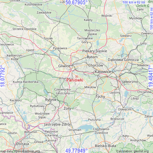
Paniówki GPS coordinates[2]
50° 13' 53.004" North, 18° 46' 51.744" East
| Map corner | latitude | longitude |
|---|---|---|
| Upper-left | 50.67905°, | 18.07792° |
| Center: | 50.23139°, | 18.78104° |
| Lower-right: | 49.77949°, | 19.48417° |
| Map W x H: | 100×100 km | = 62.1×62.1mi |
| max Lat: | 54.83135° ⇑73.7% North |
| Paniówki: | 50.23139° |
| min Lat: | ⇓26.3% South 49.21328° |
| min Long | Paniówki | max Long |
| 14.20249° | 18.78104° | 24.03723° |
| W 36.3%⇐ | ⇒63.7% E |
Elevation
Elevation of Paniówki is 234 m = 768 ft, and this is 42.6 m = 140 ft above average elevation for this country.
| Max E: |
974 m = 3196 ft | 28.4% |
| Paniówki | 234 m 768 ft | |
| Avg. | 191.4 m = 628 ft | |
Min E: |
-3 m = -10 ft | 71.6% |
See also: Poland elevation on elevation.city.
Geographical zone
Paniówki is located in North temperate zone (between Tropic of Cancer and the Arctic Circle). Distance of this North polar circle is 1816 km =1128.4 mi to North.| Distance of | km | miles | from Paniówki |
|---|---|---|---|
| North Pole | 4421.9 | 2747.6 | to North |
| Arctic Circle | 1816 | 1128.4 | to North |
| Tropic Cancer | 2979.3 | 1851.3 | to South |
| Equator | 5585.2 | 3470.5 | to South |


Nearby cities:
15 places around Paniówki: (largest is in red/bold)
• Bełk
12.1 km =7.5 mi,  202°
202°
• Czerwionka-Leszczyny
11.7 km =7.3 mi,  219°
219°
• Gardawice
12.8 km =8 mi,  173°
173°
• Gierałtowice
3.4 km =2.1 mi,  257°
257°
• Gliwice
10.5 km =6.5 mi,  314°
314°
• Knurów
9.4 km =5.8 mi, 262°
• Mikołów
11 km =6.8 mi,  127°
127°
• Ornontowice
4.6 km =2.9 mi, 204°
• Orzesze
8.4 km =5.2 mi,  180°
180°
• Przyszowice
3.1 km =1.9 mi, 307°
• Ruda Śląska
6.1 km =3.8 mi,  60°
60°
• Zabrze
10.4 km =6.5 mi,  1°
1°
• Łaziska Górne
10.1 km =6.3 mi,  154°
154°
• Świętochłowice
12.1 km =7.5 mi,  53°
53°
• Żernica
11.9 km =7.4 mi,  278°
278°
Sources, notices
• [Note1] Compared only with cities in Poland existing in our database
• [Src1] Map data: © OpenStreetMap contributors (CC-BY-SA)
• [Src2] Other city data from geonames.org with taken over terms of usage.
• [Src3] Geographical zone / Annual Mean Temperature by Robert A. Rohde @ Wikipedia
