Świętochłowice geodata
Świętochłowice (Silesia) is a seat of a second-order administrative division; located in Poland in Europe/Warsaw (GMT+2) time zone. With population of 55,600 people, there are 93 cities with bigger population in this country. Compared to other cities in Poland, 72.2% of cities are located further ↑North; 61.7% of cities are located further →East and 83.4% of cities have lower elevation than Świętochłowice. Note1


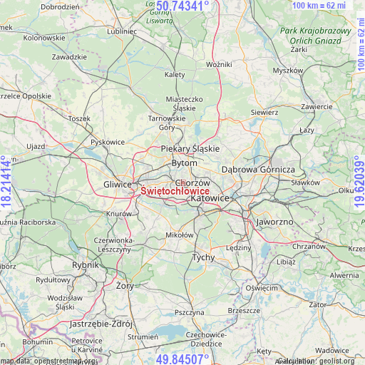
Świętochłowice GPS coordinates[2]
50° 17' 46.896" North, 18° 55' 2.136" East
| Map corner | latitude | longitude |
|---|---|---|
| Upper-left | 50.74341°, | 18.21414° |
| Center: | 50.29636°, | 18.91726° |
| Lower-right: | 49.84507°, | 19.62039° |
| Map W x H: | 99.9×99.9 km | = 62.1×62.1mi |
| max Lat: | 54.83135° ⇑72.2% North |
| Świętochłowice: | 50.29636° |
| min Lat: | ⇓27.8% South 49.21328° |
| min Long | Świętochłowi | max Long |
| 14.20249° | 18.91726° | 24.03723° |
| W 38.3%⇐ | ⇒61.7% E |
Elevation
Elevation of Świętochłowice is 282 m = 925 ft, and this is 90.6 m = 297 ft above average elevation for this country.
| Max E: |
974 m = 3196 ft | 16.6% |
| Świętochłowice | 282 m 925 ft | |
| Avg. | 191.4 m = 628 ft | |
Min E: |
-3 m = -10 ft | 83.4% |
See also: Świętochłowice elevation on elevation.city.
Geographical zone
Świętochłowice is located in North temperate zone (between Tropic of Cancer and the Arctic Circle). Distance of this North polar circle is 1808.7 km =1123.9 mi to North.| Distance of | km | miles | from Świętochłowice |
|---|---|---|---|
| North Pole | 4414.6 | 2743.1 | to North |
| Arctic Circle | 1808.7 | 1123.9 | to North |
| Tropic Cancer | 2986.5 | 1855.7 | to South |
| Equator | 5592.4 | 3475 | to South |


Nearby cities:
15 places around Świętochłowice: (largest is in red/bold)
• Bobrowniki
10.5 km =6.5 mi,  27°
27°
• Brzeziny Śląskie
7.9 km =4.9 mi,  35°
35°
• Bytom
5.8 km =3.6 mi,  10°
10°
• Chorzów
4.2 km =2.6 mi,  75°
75°
• Czeladź
11.6 km =7.2 mi, 79°
• Dobieszowice
13.1 km =8.1 mi, 31°
• Katowice
8.9 km =5.5 mi,  118°
118°
• Paniówki
12.1 km =7.5 mi,  233°
233°
• Piekary Śląskie
9.3 km =5.8 mi,  4°
4°
• Radzionków
11.6 km =7.2 mi,  354°
354°
• Ruda Śląska
6 km =3.7 mi, 225°
• Siemianowice Śląskie
8.7 km =5.4 mi,  66°
66°
• Sosnowiec
13.3 km =8.3 mi,  94°
94°
• Wojkowice
11.4 km =7.1 mi,  47°
47°
• Zabrze
9.9 km =6.2 mi,  288°
288°
Sources, notices
• [Note1] Compared only with cities in Poland existing in our database
• [Src1] Map data: © OpenStreetMap contributors (CC-BY-SA)
• [Src2] Other city data from geonames.org with taken over terms of usage.
• [Src3] Geographical zone / Annual Mean Temperature by Robert A. Rohde @ Wikipedia
