Mikołów geodata
Mikołów (Silesia) is a seat of a third-order administrative division; located in Poland in Europe/Warsaw (GMT+2) time zone. With population of 38,821 people, there are 132 cities with bigger population in this country. Compared to other cities in Poland, 75.2% of cities are located further ↑North; 61.9% of cities are located further →East and 84.4% of cities have lower elevation than Mikołów. Note1


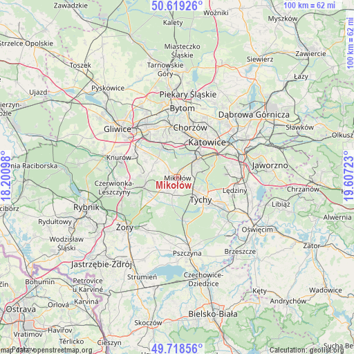
Mikołów GPS coordinates[2]
50° 10' 15.708" North, 18° 54' 14.76" East
| Map corner | latitude | longitude |
|---|---|---|
| Upper-left | 50.61926°, | 18.20098° |
| Center: | 50.17103°, | 18.9041° |
| Lower-right: | 49.71856°, | 19.60723° |
| Map W x H: | 100.1×100.1 km | = 62.2×62.2mi |
| max Lat: | 54.83135° ⇑75.2% North |
| Mikołów: | 50.17103° |
| min Lat: | ⇓24.8% South 49.21328° |
| min Long | Mikołów | max Long |
| 14.20249° | 18.9041° | 24.03723° |
| W 38.1%⇐ | ⇒61.9% E |
Elevation
Elevation of Mikołów is 287 m = 942 ft, and this is 95.6 m = 314 ft above average elevation for this country.
| Max E: |
974 m = 3196 ft | 15.6% |
| Mikołów | 287 m 942 ft | |
| Avg. | 191.4 m = 628 ft | |
Min E: |
-3 m = -10 ft | 84.4% |
See also: Poland elevation on elevation.city.
Geographical zone
Mikołów is located in North temperate zone (between Tropic of Cancer and the Arctic Circle). Distance of this North polar circle is 1822.7 km =1132.6 mi to North.| Distance of | km | miles | from Mikołów |
|---|---|---|---|
| North Pole | 4428.6 | 2751.8 | to North |
| Arctic Circle | 1822.7 | 1132.6 | to North |
| Tropic Cancer | 2972.6 | 1847.1 | to South |
| Equator | 5578.5 | 3466.3 | to South |


Nearby cities:
15 places around Mikołów: (largest is in red/bold)
• Cielmice
12.3 km =7.6 mi,  138°
138°
• Gardawice
9.6 km =6 mi,  230°
230°
• Gierałtowice
13.5 km =8.4 mi,  296°
296°
• Gostyń
7.5 km =4.7 mi,  191°
191°
• Katowice
13.1 km =8.1 mi,  42°
42°
• Kobiór
12.4 km =7.7 mi,  169°
169°
• Murcki
10.4 km =6.5 mi,  71°
71°
• Ornontowice
11 km =6.8 mi,  283°
283°
• Orzesze
9.1 km =5.7 mi,  259°
259°
• Paniówki
11 km =6.8 mi,  307°
307°
• Ruda Śląska
10.3 km =6.4 mi,  340°
340°
• Tychy
5.8 km =3.6 mi,  130°
130°
• Wyry
4.2 km =2.6 mi,  183°
183°
• Łaziska Górne
5 km =3.1 mi,  241°
241°
• Świętochłowice
14 km =8.7 mi,  3°
3°
Sources, notices
• [Note1] Compared only with cities in Poland existing in our database
• [Src1] Map data: © OpenStreetMap contributors (CC-BY-SA)
• [Src2] Other city data from geonames.org with taken over terms of usage.
• [Src3] Geographical zone / Annual Mean Temperature by Robert A. Rohde @ Wikipedia
