Zabrze geodata
Zabrze (Silesia) is a seat of a second-order administrative division; located in Poland in Europe/Warsaw (GMT+2) time zone. With population of 192,177 people, there are 19 cities with bigger population in this country. Compared to other cities in Poland, 71.4% of cities are located further ↑North; 63.6% of cities are located further →East and 78.1% of cities have lower elevation than Zabrze. Note1


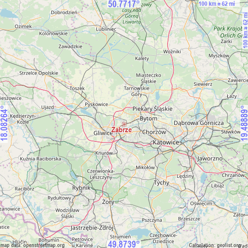
Zabrze GPS coordinates[2]
50° 19' 29.712" North, 18° 47' 8.736" East
| Map corner | latitude | longitude |
|---|---|---|
| Upper-left | 50.7717°, | 18.08264° |
| Center: | 50.32492°, | 18.78576° |
| Lower-right: | 49.8739°, | 19.48889° |
| Map W x H: | 99.8×99.8 km | = 62×62mi |
| max Lat: | 54.83135° ⇑71.4% North |
| Zabrze: | 50.32492° |
| min Lat: | ⇓28.6% South 49.21328° |
| min Long | Zabrze | max Long |
| 14.20249° | 18.78576° | 24.03723° |
| W 36.4%⇐ | ⇒63.6% E |
Elevation
Elevation of Zabrze is 258 m = 846 ft, and this is 66.6 m = 219 ft above average elevation for this country.
| Max E: |
974 m = 3196 ft | 21.9% |
| Zabrze | 258 m 846 ft | |
| Avg. | 191.4 m = 628 ft | |
Min E: |
-3 m = -10 ft | 78.1% |
See also: Zabrze elevation on elevation.city.
Geographical zone
Zabrze is located in North temperate zone (between Tropic of Cancer and the Arctic Circle). Distance of this North polar circle is 1805.6 km =1121.9 mi to North.| Distance of | km | miles | from Zabrze |
|---|---|---|---|
| North Pole | 4411.5 | 2741.2 | to North |
| Arctic Circle | 1805.6 | 1121.9 | to North |
| Tropic Cancer | 2989.7 | 1857.7 | to South |
| Equator | 5595.6 | 3476.9 | to South |


Nearby cities:
15 places around Zabrze: (largest is in red/bold)
• Brzeziny Śląskie
14.3 km =8.9 mi,  76°
76°
• Bytom
10.7 km =6.6 mi, 76°
• Chorzów
13.5 km =8.4 mi,  99°
99°
• Gierałtowice
11.7 km =7.3 mi,  198°
198°
• Gliwice
8.3 km =5.2 mi,  248°
248°
• Paniówki
10.4 km =6.5 mi,  181°
181°
• Piekary Śląskie
11.7 km =7.3 mi,  58°
58°
• Przyszowice
9 km =5.6 mi, 198°
• Pyskowice
13.7 km =8.5 mi,  307°
307°
• Radzionków
11.8 km =7.3 mi,  44°
44°
• Ruda Śląska
8.9 km =5.5 mi,  145°
145°
• Tarnowskie Góry
14.4 km =8.9 mi,  21°
21°
• Wieszowa
6.9 km =4.3 mi,  344°
344°
• Zbrosławice
10.4 km =6.5 mi,  347°
347°
• Świętochłowice
9.9 km =6.2 mi,  108°
108°
Sources, notices
• [Note1] Compared only with cities in Poland existing in our database
• [Src1] Map data: © OpenStreetMap contributors (CC-BY-SA)
• [Src2] Other city data from geonames.org with taken over terms of usage.
• [Src3] Geographical zone / Annual Mean Temperature by Robert A. Rohde @ Wikipedia
