Pakość geodata
Pakość (Kujawsko-Pomorskie) is a seat of a third-order administrative division; located in Poland in Europe/Warsaw (GMT+2) time zone. With population of 5,762 people, there are 623 cities with bigger population in this country. Compared to other cities in Poland, 81% of cities are located further ↓South; 74.4% of cities are located further →East and 88.4% of cities have higher elevation than Pakość. Note1
Administrative division(s):
- Level 1: Kujawsko-Pomorskie
- Level 2: Powiat inowrocławski
- Level 3: Pakość


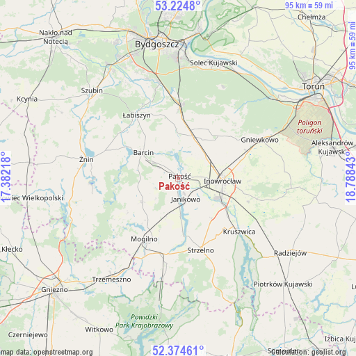
Pakość GPS coordinates[2]
52° 48' 6.408" North, 18° 5' 7.08" East
| Map corner | latitude | longitude |
|---|---|---|
| Upper-left | 53.2248°, | 17.38218° |
| Center: | 52.80178°, | 18.0853° |
| Lower-right: | 52.37461°, | 18.78843° |
| Map W x H: | 94.5×94.5 km | = 58.7×58.7mi |
| max Lat: | 54.83135° ⇑19% North |
| Pakość: | 52.80178° |
| min Lat: | ⇓81% South 49.21328° |
| min Long | Pakość | max Long |
| 14.20249° | 18.0853° | 24.03723° |
| W 25.6%⇐ | ⇒74.4% E |
Elevation
Elevation of Pakość is 80 m = 262 ft, and this is 111.4 m = 365 ft below average elevation for this country.
| Max E: |
974 m = 3196 ft | 88.4% |
| Avg. | 191.4 m = 628 ft | |
| Pakość | 80 m = 262 ft | |
Min E: |
-3 m = -10 ft | 11.6% |
See also: Poland elevation on elevation.city.
Geographical zone
Pakość is located in North temperate zone (between Tropic of Cancer and the Arctic Circle). Distance of this North polar circle is 1530.2 km =950.8 mi to North.| Distance of | km | miles | from Pakość |
|---|---|---|---|
| North Pole | 4136.1 | 2570.1 | to North |
| Arctic Circle | 1530.2 | 950.8 | to North |
| Tropic Cancer | 3265.1 | 2028.8 | to South |
| Equator | 5871 | 3648.1 | to South |


Nearby cities:
15 places around Pakość: (largest is in red/bold)
• Barcin
11.8 km =7.3 mi,  307°
307°
• Dąbrowa
11.3 km =7 mi,  237°
237°
• Gąsawa
22.5 km =14 mi,  260°
260°
• Inowrocław
12 km =7.5 mi,  91°
91°
• Janikowo
5.7 km =3.5 mi,  160°
160°
• Kościelec
5 km =3.1 mi,  100°
100°
• Krotoszyn
10.1 km =6.3 mi,  300°
300°
• Kruszwica
21.7 km =13.5 mi,  130°
130°
• Mogilno
18.2 km =11.3 mi,  208°
208°
• Nowa Wieś Wielka
18.9 km =11.7 mi,  1°
1°
• Rojewo
17 km =10.6 mi,  49°
49°
• Strzelno
20.2 km =12.6 mi, 163°
• Wierzchosławice
19.7 km =12.2 mi,  67°
67°
• Złotniki Kujawskie
11.6 km =7.2 mi,  20°
20°
• Łabiszyn
20.1 km =12.5 mi,  326°
326°
Sources, notices
• [Note1] Compared only with cities in Poland existing in our database
• [Src1] Map data: © OpenStreetMap contributors (CC-BY-SA)
• [Src2] Other city data from geonames.org with taken over terms of usage.
• [Src3] Geographical zone / Annual Mean Temperature by Robert A. Rohde @ Wikipedia
