Gąsawa geodata
Gąsawa (Kujawsko-Pomorskie) is a seat of a third-order administrative division; located in Poland in Europe/Warsaw (GMT+2) time zone. With population of 1,400 people, there are 1959 cities with bigger population in this country. Compared to other cities in Poland, 80.5% of cities are located further ↓South; 77.6% of cities are located further →East and 86.3% of cities have higher elevation than Gąsawa. Note1


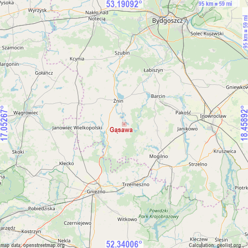
Gąsawa GPS coordinates[2]
52° 46' 3.252" North, 17° 45' 20.844" East
| Map corner | latitude | longitude |
|---|---|---|
| Upper-left | 53.19092°, | 17.05267° |
| Center: | 52.76757°, | 17.75579° |
| Lower-right: | 52.34006°, | 18.45892° |
| Map W x H: | 94.6×94.6 km | = 58.8×58.8mi |
| max Lat: | 54.83135° ⇑19.5% North |
| Gąsawa: | 52.76757° |
| min Lat: | ⇓80.5% South 49.21328° |
| min Long | Gąsawa | max Long |
| 14.20249° | 17.75579° | 24.03723° |
| W 22.4%⇐ | ⇒77.6% E |
Elevation
Elevation of Gąsawa is 86 m = 282 ft, and this is 105.4 m = 346 ft below average elevation for this country.
| Max E: |
974 m = 3196 ft | 86.3% |
| Avg. | 191.4 m = 628 ft | |
| Gąsawa | 86 m = 282 ft | |
Min E: |
-3 m = -10 ft | 13.7% |
See also: Poland elevation on elevation.city.
Geographical zone
Gąsawa is located in North temperate zone (between Tropic of Cancer and the Arctic Circle). Distance of this North polar circle is 1534 km =953.2 mi to North.| Distance of | km | miles | from Gąsawa |
|---|---|---|---|
| North Pole | 4139.9 | 2572.4 | to North |
| Arctic Circle | 1534 | 953.2 | to North |
| Tropic Cancer | 3261.3 | 2026.5 | to South |
| Equator | 5867.2 | 3645.7 | to South |


Nearby cities:
15 places around Gąsawa: (largest is in red/bold)
• Barcin
16.8 km =10.4 mi,  49°
49°
• Brzyskorzystewko
14.5 km =9 mi,  342°
342°
• Damasławek
18.9 km =11.7 mi,  295°
295°
• Dąbrowa
12.8 km =8 mi,  100°
100°
• Janowiec Wielkopolski
17.9 km =11.1 mi,  265°
265°
• Krotoszyn
16.2 km =10.1 mi,  56°
56°
• Królikowo
23.1 km =14.4 mi, 337°
• Mieleszyn
20.6 km =12.8 mi,  237°
237°
• Mogilno
18.2 km =11.3 mi,  132°
132°
• Pakość
22.5 km =14 mi,  80°
80°
• Rogowo
8.5 km =5.3 mi, 235°
• Sarbinowo
11.1 km =6.9 mi,  327°
327°
• Trzemeszno
23.4 km =14.5 mi,  168°
168°
• Łabiszyn
23.3 km =14.5 mi,  28°
28°
• Żnin
9.4 km =5.8 mi,  345°
345°
Sources, notices
• [Note1] Compared only with cities in Poland existing in our database
• [Src1] Map data: © OpenStreetMap contributors (CC-BY-SA)
• [Src2] Other city data from geonames.org with taken over terms of usage.
• [Src3] Geographical zone / Annual Mean Temperature by Robert A. Rohde @ Wikipedia
