Mogilno geodata
Mogilno (Kujawsko-Pomorskie) is a seat of a third-order administrative division; located in Poland in Europe/Warsaw (GMT+2) time zone. With population of 12,465 people, there are 380 cities with bigger population in this country. Compared to other cities in Poland, 78.7% of cities are located further ↓South; 75.7% of cities are located further →East and 83.2% of cities have higher elevation than Mogilno. Note1


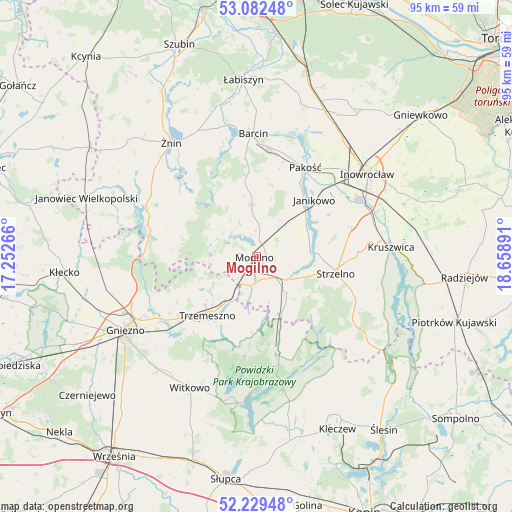
Mogilno GPS coordinates[2]
52° 39' 29.016" North, 17° 57' 20.808" East
| Map corner | latitude | longitude |
|---|---|---|
| Upper-left | 53.08248°, | 17.25266° |
| Center: | 52.65806°, | 17.95578° |
| Lower-right: | 52.22948°, | 18.65891° |
| Map W x H: | 94.8×94.8 km | = 58.9×58.9mi |
| max Lat: | 54.83135° ⇑21.3% North |
| Mogilno: | 52.65806° |
| min Lat: | ⇓78.7% South 49.21328° |
| min Long | Mogilno | max Long |
| 14.20249° | 17.95578° | 24.03723° |
| W 24.3%⇐ | ⇒75.7% E |
Elevation
Elevation of Mogilno is 93 m = 305 ft, and this is 98.4 m = 323 ft below average elevation for this country.
| Max E: |
974 m = 3196 ft | 83.2% |
| Avg. | 191.4 m = 628 ft | |
| Mogilno | 93 m = 305 ft | |
Min E: |
-3 m = -10 ft | 16.8% |
See also: Poland elevation on elevation.city.
Geographical zone
Mogilno is located in North temperate zone (between Tropic of Cancer and the Arctic Circle). Distance of this North polar circle is 1546.1 km =960.7 mi to North.| Distance of | km | miles | from Mogilno |
|---|---|---|---|
| North Pole | 4152 | 2579.9 | to North |
| Arctic Circle | 1546.1 | 960.7 | to North |
| Tropic Cancer | 3249.1 | 2018.9 | to South |
| Equator | 5855 | 3638.1 | to South |


Nearby cities:
15 places around Mogilno: (largest is in red/bold)
• Barcin
23.1 km =14.4 mi,  358°
358°
• Dąbrowa
9.9 km =6.2 mi, 355°
• Gąsawa
18.2 km =11.3 mi,  312°
312°
• Janikowo
15 km =9.3 mi,  45°
45°
• Jeziora Wielkie
25.4 km =15.8 mi,  123°
123°
• Kościelec
20.3 km =12.6 mi,  42°
42°
• Krotoszyn
21.1 km =13.1 mi,  0°
0°
• Kruszwica
25.4 km =15.8 mi,  85°
85°
• Orchowo
17 km =10.6 mi,  166°
166°
• Pakość
18.2 km =11.3 mi,  28°
28°
• Rogowo
21.8 km =13.5 mi,  289°
289°
• Strzelno
15 km =9.3 mi,  102°
102°
• Trzemeszno
14 km =8.7 mi,  219°
219°
• Wilczogóra
25 km =15.5 mi,  145°
145°
• Wilczyn
23.4 km =14.5 mi,  143°
143°
Sources, notices
• [Note1] Compared only with cities in Poland existing in our database
• [Src1] Map data: © OpenStreetMap contributors (CC-BY-SA)
• [Src2] Other city data from geonames.org with taken over terms of usage.
• [Src3] Geographical zone / Annual Mean Temperature by Robert A. Rohde @ Wikipedia
