Łabiszyn geodata
Łabiszyn (Kujawsko-Pomorskie) is a seat of a third-order administrative division; located in Poland in Europe/Warsaw (GMT+2) time zone. With population of 4,454 people, there are 742 cities with bigger population in this country. Compared to other cities in Poland, 83% of cities are located further ↓South; 76.1% of cities are located further →East and 89.9% of cities have higher elevation than Łabiszyn. Note1


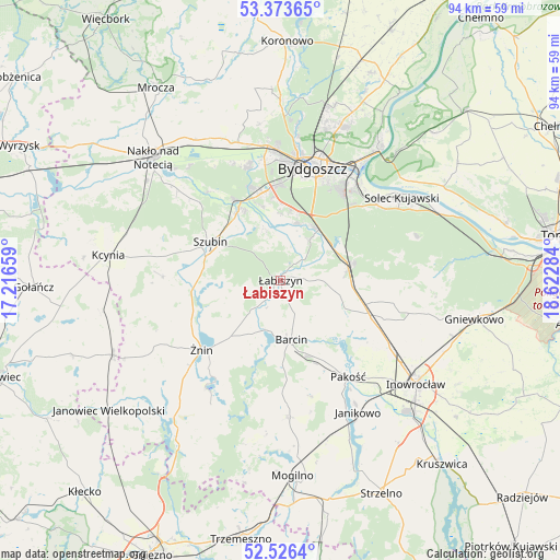
Łabiszyn GPS coordinates[2]
52° 57' 7.56" North, 17° 55' 10.956" East
| Map corner | latitude | longitude |
|---|---|---|
| Upper-left | 53.37365°, | 17.21659° |
| Center: | 52.9521°, | 17.91971° |
| Lower-right: | 52.5264°, | 18.62284° |
| Map W x H: | 94.2×94.2 km | = 58.5×58.5mi |
| max Lat: | 54.83135° ⇑17% North |
| Łabiszyn: | 52.9521° |
| min Lat: | ⇓83% South 49.21328° |
| min Long | Łabiszyn | max Long |
| 14.20249° | 17.91971° | 24.03723° |
| W 23.9%⇐ | ⇒76.1% E |
Elevation
Elevation of Łabiszyn is 76 m = 249 ft, and this is 115.4 m = 379 ft below average elevation for this country.
| Max E: |
974 m = 3196 ft | 89.9% |
| Avg. | 191.4 m = 628 ft | |
| Łabiszyn | 76 m = 249 ft | |
Min E: |
-3 m = -10 ft | 10.1% |
See also: Poland elevation on elevation.city.
Geographical zone
Łabiszyn is located in North temperate zone (between Tropic of Cancer and the Arctic Circle). Distance of this North polar circle is 1513.5 km =940.4 mi to North.| Distance of | km | miles | from Łabiszyn |
|---|---|---|---|
| North Pole | 4119.3 | 2559.6 | to North |
| Arctic Circle | 1513.5 | 940.4 | to North |
| Tropic Cancer | 3281.8 | 2039.2 | to South |
| Equator | 5887.7 | 3658.4 | to South |


Nearby cities:
15 places around Łabiszyn: (largest is in red/bold)
• Barcin
9.7 km =6 mi,  169°
169°
• Białe Błota
15.9 km =9.9 mi,  359°
359°
• Brzyskorzystewko
16.7 km =10.4 mi,  246°
246°
• Bydgoszcz
19.9 km =12.4 mi,  17°
17°
• Dąbrowa
22.9 km =14.2 mi,  176°
176°
• Gąsawa
23.3 km =14.5 mi,  208°
208°
• Kołaczkowo
12.8 km =8 mi,  314°
314°
• Krotoszyn
11.8 km =7.3 mi, 168°
• Królikowo
19.8 km =12.3 mi,  272°
272°
• Nowa Wieś Wielka
11.6 km =7.2 mi,  79°
79°
• Pakość
20.1 km =12.5 mi,  146°
146°
• Sarbinowo
20.3 km =12.6 mi,  236°
236°
• Szubin
13.6 km =8.5 mi,  298°
298°
• Złotniki Kujawskie
16.2 km =10.1 mi,  111°
111°
• Żnin
17.6 km =10.9 mi,  229°
229°
Sources, notices
• [Note1] Compared only with cities in Poland existing in our database
• [Src1] Map data: © OpenStreetMap contributors (CC-BY-SA)
• [Src2] Other city data from geonames.org with taken over terms of usage.
• [Src3] Geographical zone / Annual Mean Temperature by Robert A. Rohde @ Wikipedia
