Dąbrowa geodata
Dąbrowa (Kujawsko-Pomorskie) is a seat of a third-order administrative division; located in Poland in Europe/Warsaw (GMT+2) time zone. With population of 1,101 people, there are 2304 cities with bigger population in this country. Compared to other cities in Poland, 80% of cities are located further ↓South; 75.8% of cities are located further →East and 77.6% of cities have higher elevation than Dąbrowa. Note1


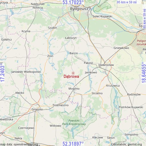
Dąbrowa GPS coordinates[2]
52° 44' 48.048" North, 17° 56' 36.312" East
| Map corner | latitude | longitude |
|---|---|---|
| Upper-left | 53.17023°, | 17.2403° |
| Center: | 52.74668°, | 17.94342° |
| Lower-right: | 52.31897°, | 18.64655° |
| Map W x H: | 94.7×94.6 km | = 58.8×58.8mi |
| max Lat: | 54.83135° ⇑20% North |
| Dąbrowa: | 52.74668° |
| min Lat: | ⇓80% South 49.21328° |
| min Long | Dąbrowa | max Long |
| 14.20249° | 17.94342° | 24.03723° |
| W 24.2%⇐ | ⇒75.8% E |
Elevation
Elevation of Dąbrowa is 104 m = 341 ft, and this is 87.4 m = 287 ft below average elevation for this country.
| Max E: |
974 m = 3196 ft | 77.6% |
| Avg. | 191.4 m = 628 ft | |
| Dąbrowa | 104 m = 341 ft | |
Min E: |
-3 m = -10 ft | 22.4% |
See also: Poland elevation on elevation.city.
Geographical zone
Dąbrowa is located in North temperate zone (between Tropic of Cancer and the Arctic Circle). Distance of this North polar circle is 1536.3 km =954.6 mi to North.| Distance of | km | miles | from Dąbrowa |
|---|---|---|---|
| North Pole | 4142.2 | 2573.8 | to North |
| Arctic Circle | 1536.3 | 954.6 | to North |
| Tropic Cancer | 3259 | 2025 | to South |
| Equator | 5864.9 | 3644.3 | to South |


Nearby cities:
15 places around Dąbrowa: (largest is in red/bold)
• Barcin
13.3 km =8.3 mi,  0°
0°
• Gąsawa
12.8 km =8 mi,  280°
280°
• Inowrocław
22.3 km =13.9 mi,  74°
74°
• Janikowo
11.5 km =7.1 mi,  86°
86°
• Kościelec
15.4 km =9.6 mi, 70°
• Krotoszyn
11.3 km =7 mi, 4°
• Mogilno
9.9 km =6.2 mi,  175°
175°
• Pakość
11.3 km =7 mi,  57°
57°
• Rogowo
19.8 km =12.3 mi,  262°
262°
• Sarbinowo
21.9 km =13.6 mi,  302°
302°
• Strzelno
20.3 km =12.6 mi,  130°
130°
• Trzemeszno
22.1 km =13.7 mi,  201°
201°
• Złotniki Kujawskie
21.8 km =13.5 mi,  38°
38°
• Łabiszyn
22.9 km =14.2 mi,  356°
356°
• Żnin
18.9 km =11.7 mi,  307°
307°
Sources, notices
• [Note1] Compared only with cities in Poland existing in our database
• [Src1] Map data: © OpenStreetMap contributors (CC-BY-SA)
• [Src2] Other city data from geonames.org with taken over terms of usage.
• [Src3] Geographical zone / Annual Mean Temperature by Robert A. Rohde @ Wikipedia
