Ozimek geodata
Ozimek (Opole Voivodeship) is a populated place; located in Poland in Europe/Warsaw (GMT+2) time zone. With population of 9,963 people, there are 448 cities with bigger population in this country. Compared to other cities in Poland, 63.1% of cities are located further ↑North; 72.4% of cities are located further →East and 54.4% of cities have lower elevation than Ozimek. Note1


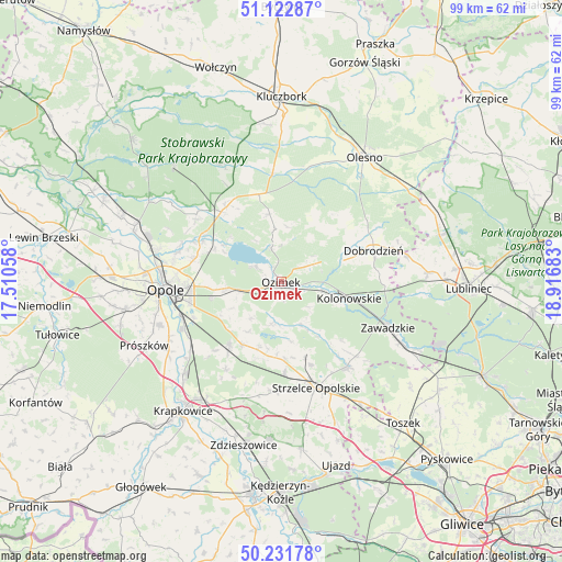
Ozimek GPS coordinates[2]
50° 40' 45.984" North, 18° 12' 49.32" East
| Map corner | latitude | longitude |
|---|---|---|
| Upper-left | 51.12287°, | 17.51058° |
| Center: | 50.67944°, | 18.2137° |
| Lower-right: | 50.23178°, | 18.91683° |
| Map W x H: | 99.1×99.1 km | = 61.6×61.6mi |
| max Lat: | 54.83135° ⇑63.1% North |
| Ozimek: | 50.67944° |
| min Lat: | ⇓36.9% South 49.21328° |
| min Long | Ozimek | max Long |
| 14.20249° | 18.2137° | 24.03723° |
| W 27.6%⇐ | ⇒72.4% E |
Elevation
Elevation of Ozimek is 183 m = 600 ft, and this is 8.4 m = 28 ft below average elevation for this country.
| Max E: |
974 m = 3196 ft | 45.6% |
| Avg. | 191.4 m = 628 ft | |
| Ozimek | 183 m = 600 ft | |
Min E: |
-3 m = -10 ft | 54.4% |
See also: Poland elevation on elevation.city.
Geographical zone
Ozimek is located in North temperate zone (between Tropic of Cancer and the Arctic Circle). Distance of this North polar circle is 1766.1 km =1097.4 mi to North.| Distance of | km | miles | from Ozimek |
|---|---|---|---|
| North Pole | 4372 | 2716.6 | to North |
| Arctic Circle | 1766.1 | 1097.4 | to North |
| Tropic Cancer | 3029.1 | 1882.2 | to South |
| Equator | 5635 | 3501.4 | to South |


Nearby cities:
15 places around Ozimek: (largest is in red/bold)
• Bierdzany
16 km =9.9 mi,  345°
345°
• Chrząstowice
10 km =6.2 mi,  261°
261°
• Dobrodzień
17.2 km =10.7 mi,  71°
71°
• Izbicko
12.7 km =7.9 mi,  198°
198°
• Jemielnica
18.9 km =11.7 mi,  142°
142°
• Kolonowskie
12.4 km =7.7 mi,  103°
103°
• Kosorowice
16.9 km =10.5 mi,  224°
224°
• Nakło
13 km =8.1 mi,  211°
211°
• Strzelce Opolskie
19.7 km =12.2 mi,  161°
161°
• Tarnów Opolski
14.7 km =9.1 mi, 218°
• Turawa
11.8 km =7.3 mi,  305°
305°
• Węgry
15.5 km =9.6 mi,  297°
297°
• Zębowice
13.1 km =8.1 mi,  44°
44°
• Łaziska
14.9 km =9.3 mi,  134°
134°
• Łubniany
19.1 km =11.9 mi, 308°
Sources, notices
• [Note1] Compared only with cities in Poland existing in our database
• [Src1] Map data: © OpenStreetMap contributors (CC-BY-SA)
• [Src2] Other city data from geonames.org with taken over terms of usage.
• [Src3] Geographical zone / Annual Mean Temperature by Robert A. Rohde @ Wikipedia
