Turawa geodata
Turawa (Opole Voivodeship) is a populated place; located in Poland in Europe/Warsaw (GMT+2) time zone. With population of 900 people, there are 2674 cities with bigger population in this country. Compared to other cities in Poland, 61.7% of cities are located further ↑North; 74.5% of cities are located further →East and 50.8% of cities have lower elevation than Turawa. Note1


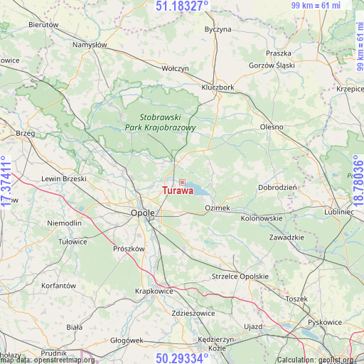
Turawa GPS coordinates[2]
50° 44' 25.512" North, 18° 4' 38.028" East
| Map corner | latitude | longitude |
|---|---|---|
| Upper-left | 51.18327°, | 17.37411° |
| Center: | 50.74042°, | 18.07723° |
| Lower-right: | 50.29334°, | 18.78036° |
| Map W x H: | 99×98.9 km | = 61.5×61.5mi |
| max Lat: | 54.83135° ⇑61.7% North |
| Turawa: | 50.74042° |
| min Lat: | ⇓38.3% South 49.21328° |
| min Long | Turawa | max Long |
| 14.20249° | 18.07723° | 24.03723° |
| W 25.5%⇐ | ⇒74.5% E |
Elevation
Elevation of Turawa is 174 m = 571 ft, and this is 17.4 m = 57 ft below average elevation for this country.
| Max E: |
974 m = 3196 ft | 49.2% |
| Avg. | 191.4 m = 628 ft | |
| Turawa | 174 m = 571 ft | |
Min E: |
-3 m = -10 ft | 50.8% |
See also: Poland elevation on elevation.city.
Geographical zone
Turawa is located in North temperate zone (between Tropic of Cancer and the Arctic Circle). Distance of this North polar circle is 1759.4 km =1093.2 mi to North.| Distance of | km | miles | from Turawa |
|---|---|---|---|
| North Pole | 4365.3 | 2712.5 | to North |
| Arctic Circle | 1759.4 | 1093.2 | to North |
| Tropic Cancer | 3035.9 | 1886.4 | to South |
| Equator | 5641.8 | 3505.7 | to South |


Nearby cities:
15 places around Turawa: (largest is in red/bold)
• Bierdzany
10.4 km =6.5 mi,  33°
33°
• Chmielowice
17.9 km =11.1 mi,  235°
235°
• Chrząstowice
8.3 km =5.2 mi,  182°
182°
• Czarnowąsy
12.7 km =7.9 mi,  264°
264°
• Dobrzeń Wielki
16.5 km =10.3 mi,  280°
280°
• Kup
15.5 km =9.6 mi,  298°
298°
• Lasowice Wielkie
17.8 km =11.1 mi,  36°
36°
• Murów
16.5 km =10.3 mi,  325°
325°
• Nakło
18.1 km =11.2 mi,  170°
170°
• Opole
13.1 km =8.1 mi,  234°
234°
• Ozimek
11.8 km =7.3 mi,  125°
125°
• Swierkle
10.6 km =6.6 mi, 284°
• Tarnów Opolski
18.3 km =11.4 mi, 178°
• Węgry
4.2 km =2.6 mi,  274°
274°
• Łubniany
7.4 km =4.6 mi,  313°
313°
Sources, notices
• [Note1] Compared only with cities in Poland existing in our database
• [Src1] Map data: © OpenStreetMap contributors (CC-BY-SA)
• [Src2] Other city data from geonames.org with taken over terms of usage.
• [Src3] Geographical zone / Annual Mean Temperature by Robert A. Rohde @ Wikipedia
