Strzelce Opolskie geodata
Strzelce Opolskie (Opole Voivodeship) is a seat of a second-order administrative division; located in Poland in Europe/Warsaw (GMT+2) time zone. With population of 20,241 people, there are 241 cities with bigger population in this country. Compared to other cities in Poland, 67.1% of cities are located further ↑North; 71.3% of cities are located further →East and 72.1% of cities have lower elevation than Strzelce Opolskie. Note1
Administrative division(s):
- Level 1: Opole Voivodeship
- Level 2: Powiat strzelecki
- Level 3: Strzelce Opolskie


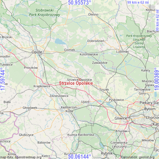
Strzelce Opolskie GPS coordinates[2]
50° 30' 38.52" North, 18° 18' 2.016" East
| Map corner | latitude | longitude |
|---|---|---|
| Upper-left | 50.95573°, | 17.59744° |
| Center: | 50.5107°, | 18.30056° |
| Lower-right: | 50.06144°, | 19.00369° |
| Map W x H: | 99.4×99.4 km | = 61.8×61.8mi |
| max Lat: | 54.83135° ⇑67.1% North |
| Strzelce Opolskie: | 50.5107° |
| min Lat: | ⇓32.9% South 49.21328° |
| min Long | Strzelce Opolsk | max Long |
| 14.20249° | 18.30056° | 24.03723° |
| W 28.7%⇐ | ⇒71.3% E |
Elevation
Elevation of Strzelce Opolskie is 236 m = 774 ft, and this is 44.6 m = 146 ft above average elevation for this country.
| Max E: |
974 m = 3196 ft | 27.9% |
| Strzelce Opolskie | 236 m 774 ft | |
| Avg. | 191.4 m = 628 ft | |
Min E: |
-3 m = -10 ft | 72.1% |
See also: Poland elevation on elevation.city.
Geographical zone
Strzelce Opolskie is located in North temperate zone (between Tropic of Cancer and the Arctic Circle). Distance of this North polar circle is 1784.9 km =1109.1 mi to North.| Distance of | km | miles | from Strzelce Opolskie |
|---|---|---|---|
| North Pole | 4390.8 | 2728.3 | to North |
| Arctic Circle | 1784.9 | 1109.1 | to North |
| Tropic Cancer | 3010.3 | 1870.5 | to South |
| Equator | 5616.3 | 3489.8 | to South |


Nearby cities:
15 places around Strzelce Opolskie: (largest is in red/bold)
• Izbicko
12.3 km =7.6 mi,  303°
303°
• Januszkowice
17.6 km =10.9 mi,  221°
221°
• Jemielnica
6.7 km =4.2 mi,  54°
54°
• Kolonowskie
16.9 km =10.5 mi,  20°
20°
• Leśnica
12 km =7.5 mi, 222°
• Nakło
15 km =9.3 mi, 300°
• Raszowa
15.3 km =9.5 mi,  214°
214°
• Rozwadza
16.5 km =10.3 mi,  239°
239°
• Sławięcice
15.5 km =9.6 mi,  174°
174°
• Tarnów Opolski
17 km =10.6 mi, 295°
• Toszek
16.9 km =10.5 mi,  111°
111°
• Ujazd
13.9 km =8.6 mi, 165°
• Zawadzkie
16.7 km =10.4 mi, 51°
• Zdzieszowice
15.8 km =9.8 mi,  232°
232°
• Łaziska
9.6 km =6 mi,  28°
28°
Sources, notices
• [Note1] Compared only with cities in Poland existing in our database
• [Src1] Map data: © OpenStreetMap contributors (CC-BY-SA)
• [Src2] Other city data from geonames.org with taken over terms of usage.
• [Src3] Geographical zone / Annual Mean Temperature by Robert A. Rohde @ Wikipedia
