Bierdzany geodata
Bierdzany (Opole Voivodeship) is a populated place; located in Poland in Europe/Warsaw (GMT+2) time zone. With population of 1,072 people, there are 2386 cities with bigger population in this country. Compared to other cities in Poland, 59.8% of cities are located further ↑North; 73.3% of cities are located further →East and 59.2% of cities have lower elevation than Bierdzany. Note1


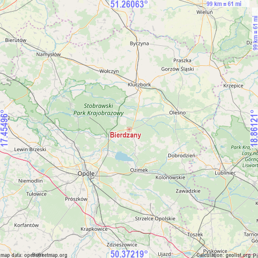
Bierdzany GPS coordinates[2]
50° 49' 6.672" North, 18° 9' 29.088" East
| Map corner | latitude | longitude |
|---|---|---|
| Upper-left | 51.26063°, | 17.45496° |
| Center: | 50.81852°, | 18.15808° |
| Lower-right: | 50.37219°, | 18.86121° |
| Map W x H: | 98.8×98.8 km | = 61.4×61.4mi |
| max Lat: | 54.83135° ⇑59.8% North |
| Bierdzany: | 50.81852° |
| min Lat: | ⇓40.2% South 49.21328° |
| min Long | Bierdzany | max Long |
| 14.20249° | 18.15808° | 24.03723° |
| W 26.7%⇐ | ⇒73.3% E |
Elevation
Elevation of Bierdzany is 198 m = 650 ft, and this is 6.6 m = 22 ft above average elevation for this country.
| Max E: |
974 m = 3196 ft | 40.8% |
| Bierdzany | 198 m 650 ft | |
| Avg. | 191.4 m = 628 ft | |
Min E: |
-3 m = -10 ft | 59.2% |
See also: Poland elevation on elevation.city.
Geographical zone
Bierdzany is located in North temperate zone (between Tropic of Cancer and the Arctic Circle). Distance of this North polar circle is 1750.7 km =1087.8 mi to North.| Distance of | km | miles | from Bierdzany |
|---|---|---|---|
| North Pole | 4356.6 | 2707.1 | to North |
| Arctic Circle | 1750.7 | 1087.8 | to North |
| Tropic Cancer | 3044.6 | 1891.8 | to South |
| Equator | 5650.5 | 3511.1 | to South |


Nearby cities:
15 places around Bierdzany: (largest is in red/bold)
• Borkowice
13.6 km =8.5 mi,  359°
359°
• Chrząstowice
18 km =11.2 mi,  199°
199°
• Kluczbork
17.7 km =11 mi,  13°
13°
• Kup
19.3 km =12 mi,  266°
266°
• Lasowice Małe
11.8 km =7.3 mi,  35°
35°
• Lasowice Wielkie
7.5 km =4.7 mi, 40°
• Murów
15.7 km =9.8 mi,  288°
288°
• Olesno
19.6 km =12.2 mi,  70°
70°
• Ozimek
16 km =9.9 mi,  165°
165°
• Swierkle
17.1 km =10.6 mi,  249°
249°
• Turawa
10.4 km =6.5 mi,  213°
213°
• Wojciechów
18.6 km =11.6 mi,  62°
62°
• Węgry
13 km =8.1 mi,  229°
229°
• Zębowice
14.5 km =9 mi,  115°
115°
• Łubniany
11.6 km =7.2 mi, 251°
Sources, notices
• [Note1] Compared only with cities in Poland existing in our database
• [Src1] Map data: © OpenStreetMap contributors (CC-BY-SA)
• [Src2] Other city data from geonames.org with taken over terms of usage.
• [Src3] Geographical zone / Annual Mean Temperature by Robert A. Rohde @ Wikipedia
